Sant'Agata Feltria geodata
Sant'Agata Feltria (Emilia-Romagna) is a seat of a third-order administrative division; located in Italy in Europe/Rome (GMT+2) time zone. With population of 909 people, there are 7095 cities with bigger population in this country. Compared to other cities in Italy, 56.2% of cities are located further ↑North; 58.7% of cities are located further ←West and 83.3% of cities have lower elevation than Sant'Agata Feltria. Note1
Administrative division(s):
- Level 1: Emilia-Romagna
- Level 2: Provincia di Rimini
- Level 3: Sant'Agata Feltria


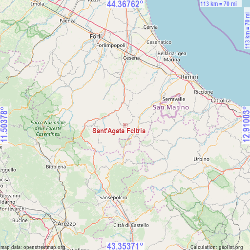
Sant'Agata Feltria GPS coordinates[2]
43° 51' 46.152" North, 12° 12' 24.84" East
| Map corner | latitude | longitude |
|---|---|---|
| Upper-left | 44.36762°, | 11.50378° |
| Center: | 43.86282°, | 12.2069° |
| Lower-right: | 43.35371°, | 12.91003° |
| Map W x H: | 112.7×112.7 km | = 70×70mi |
| max Lat: | 47.04031° ⇑56.2% North |
| Sant'Agata Feltria: | 43.86282° |
| min Lat: | ⇓43.8% South 35.50142° |
| min Long | Sant'Agata Felt | max Long |
| 6.69888° | 12.2069° | 18.48682° |
| W 58.7%⇐ | ⇒41.3% E |
Elevation
Elevation of Sant'Agata Feltria is 576 m = 1890 ft, and this is 269.3 m = 884 ft above average elevation for this country.
| Max E: |
2085 m = 6841 ft | 16.7% |
| Sant'Agata Feltria | 576 m 1890 ft | |
| Avg. | 306.7 m = 1006 ft | |
Min E: |
-4 m = -13 ft | 83.3% |
See also: Italy elevation on elevation.city.
Geographical zone
Sant'Agata Feltria is located in North temperate zone (between Tropic of Cancer and the Arctic Circle). Distance of this Northern Tropic circle is 2271.2 km =1411.3 mi to South.| Distance of | km | miles | from Sant'Agata Feltria |
|---|---|---|---|
| North Pole | 5130 | 3187.6 | to North |
| Arctic Circle | 2524.1 | 1568.4 | to North |
| Tropic Cancer | 2271.2 | 1411.3 | to South |
| Equator | 4877.1 | 3030.5 | to South |


Nearby cities:
15 places around Sant'Agata Feltria: (largest is in red/bold)
• Alfero
12.3 km =7.6 mi,  261°
261°
• Ca' Fusino
8.1 km =5 mi,  56°
56°
• Carpegna
13.7 km =8.5 mi,  131°
131°
• Casteldelci
9 km =5.6 mi,  207°
207°
• Mercato Saraceno
11.1 km =6.9 mi,  355°
355°
• Monte Castello
9.7 km =6 mi,  349°
349°
• Novafeltria
7.5 km =4.7 mi, 61°
• Pennabilli
7 km =4.3 mi,  136°
136°
• Perticara
5.5 km =3.4 mi,  30°
30°
• San Leo
11.6 km =7.2 mi,  71°
71°
• Sarsina
8.2 km =5.1 mi,  320°
320°
• Secchiano
11.1 km =6.9 mi,  52°
52°
• Serra di Maiolo
8.4 km =5.2 mi,  82°
82°
• Talamello
7.9 km =4.9 mi, 52°
• Villagrande
12.5 km =7.8 mi,  101°
101°
Sources, notices
• [Note1] Compared only with cities in Italy existing in our database
• [Src1] Map data: © OpenStreetMap contributors (CC-BY-SA)
• [Src2] Other city data from geonames.org with taken over terms of usage.
• [Src3] Geographical zone / Annual Mean Temperature by Robert A. Rohde @ Wikipedia
