San Gregorio Matese geodata
San Gregorio Matese (Campania) is a seat of a third-order administrative division; located in Italy in Europe/Rome (GMT+2) time zone. With population of 899 people, there are 7161 cities with bigger population in this country. Compared to other cities in Italy, 75.6% of cities are located further ↑North; 81.5% of cities are located further ←West and 92.3% of cities have lower elevation than San Gregorio Matese. Note1
Administrative division(s):
- Level 1: Campania
- Level 2: Provincia di Caserta
- Level 3: San Gregorio Matese


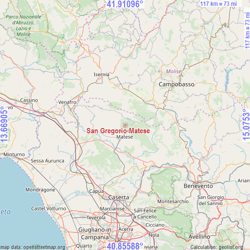
San Gregorio Matese GPS coordinates[2]
41° 23' 8.016" North, 14° 22' 19.812" East
| Map corner | latitude | longitude |
|---|---|---|
| Upper-left | 41.91096°, | 13.66905° |
| Center: | 41.38556°, | 14.37217° |
| Lower-right: | 40.85588°, | 15.0753° |
| Map W x H: | 117.3×117.3 km | = 72.9×72.9mi |
| max Lat: | 47.04031° ⇑75.6% North |
| San Gregorio Matese: | 41.38556° |
| min Lat: | ⇓24.4% South 35.50142° |
| min Long | San Gregorio Ma | max Long |
| 6.69888° | 14.37217° | 18.48682° |
| W 81.5%⇐ | ⇒18.5% E |
Elevation
Elevation of San Gregorio Matese is 779 m = 2556 ft, and this is 472.3 m = 1550 ft above average elevation for this country.
| Max E: |
2085 m = 6841 ft | 7.7% |
| San Gregorio Matese | 779 m 2556 ft | |
| Avg. | 306.7 m = 1006 ft | |
Min E: |
-4 m = -13 ft | 92.3% |
See also: Italy elevation on elevation.city.
Geographical zone
San Gregorio Matese is located in North temperate zone (between Tropic of Cancer and the Arctic Circle). Distance of this Northern Tropic circle is 1995.7 km =1240.1 mi to South.| Distance of | km | miles | from San Gregorio Matese |
|---|---|---|---|
| North Pole | 5405.4 | 3358.8 | to North |
| Arctic Circle | 2799.5 | 1739.5 | to North |
| Tropic Cancer | 1995.7 | 1240.1 | to South |
| Equator | 4601.6 | 2859.3 | to South |


Nearby cities:
15 places around San Gregorio Matese: (largest is in red/bold)
• Alife
7.3 km =4.5 mi,  205°
205°
• Campochiaro
13.3 km =8.3 mi,  58°
58°
• Castello del Matese
2.1 km =1.3 mi,  167°
167°
• Cusano Mutri
12.8 km =8 mi,  115°
115°
• Dragoni
13.4 km =8.3 mi, 205°
• Gioia Sannitica
11.3 km =7 mi,  147°
147°
• Letino
12.3 km =7.6 mi,  307°
307°
• Piedimonte Matese
3.9 km =2.4 mi,  185°
185°
• Raviscanina
10.9 km =6.8 mi,  261°
261°
• Roccamandolfi
12.4 km =7.7 mi,  352°
352°
• San Massimo
12.4 km =7.7 mi,  14°
14°
• San Polomatese
13 km =8.1 mi,  50°
50°
• San Potito Sannitico
5.6 km =3.5 mi,  163°
163°
• Sant'Angelo d'Alife
9.6 km =6 mi,  253°
253°
• Valle Agricola
10.6 km =6.6 mi,  294°
294°
Sources, notices
• [Note1] Compared only with cities in Italy existing in our database
• [Src1] Map data: © OpenStreetMap contributors (CC-BY-SA)
• [Src2] Other city data from geonames.org with taken over terms of usage.
• [Src3] Geographical zone / Annual Mean Temperature by Robert A. Rohde @ Wikipedia
