Valle Agricola geodata
Valle Agricola (Campania) is a seat of a third-order administrative division; located in Italy in Europe/Rome (GMT+2) time zone. With population of 971 people, there are 6772 cities with bigger population in this country. Compared to other cities in Italy, 75.4% of cities are located further ↑North; 80.4% of cities are located further ←West and 89.1% of cities have lower elevation than Valle Agricola. Note1


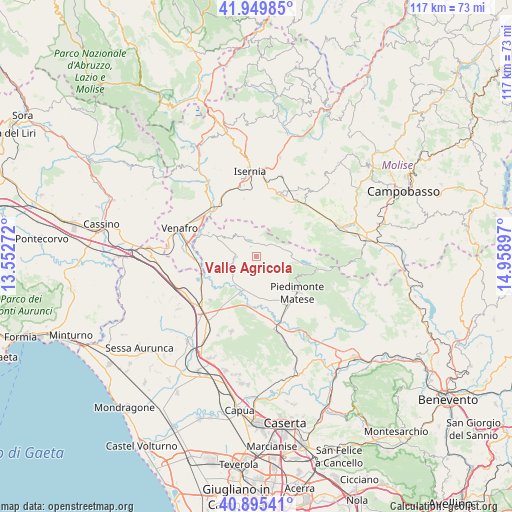
Valle Agricola GPS coordinates[2]
41° 25' 29.172" North, 14° 15' 21.024" East
| Map corner | latitude | longitude |
|---|---|---|
| Upper-left | 41.94985°, | 13.55272° |
| Center: | 41.42477°, | 14.25584° |
| Lower-right: | 40.89541°, | 14.95897° |
| Map W x H: | 117.2×117.2 km | = 72.8×72.8mi |
| max Lat: | 47.04031° ⇑75.4% North |
| Valle Agricola: | 41.42477° |
| min Lat: | ⇓24.6% South 35.50142° |
| min Long | Valle Agricola | max Long |
| 6.69888° | 14.25584° | 18.48682° |
| W 80.4%⇐ | ⇒19.6% E |
Elevation
Elevation of Valle Agricola is 696 m = 2283 ft, and this is 389.3 m = 1277 ft above average elevation for this country.
| Max E: |
2085 m = 6841 ft | 10.9% |
| Valle Agricola | 696 m 2283 ft | |
| Avg. | 306.7 m = 1006 ft | |
Min E: |
-4 m = -13 ft | 89.1% |
See also: Italy elevation on elevation.city.
Geographical zone
Valle Agricola is located in North temperate zone (between Tropic of Cancer and the Arctic Circle). Distance of this Northern Tropic circle is 2000.1 km =1242.8 mi to South.| Distance of | km | miles | from Valle Agricola |
|---|---|---|---|
| North Pole | 5401.1 | 3356.1 | to North |
| Arctic Circle | 2795.2 | 1736.9 | to North |
| Tropic Cancer | 2000.1 | 1242.8 | to South |
| Equator | 4606 | 2862 | to South |


Nearby cities:
15 places around Valle Agricola: (largest is in red/bold)
• Ailano
5.7 km =3.5 mi,  227°
227°
• Capriati A Volturno
10.3 km =6.4 mi,  297°
297°
• Castelpizzuto
11.1 km =6.9 mi,  15°
15°
• Ciorlano
8.6 km =5.3 mi,  289°
289°
• Fontegreca
7 km =4.3 mi, 300°
• Gallo
5.2 km =3.2 mi,  330°
330°
• Gallo Matese
5.1 km =3.2 mi, 329°
• Letino
3.1 km =1.9 mi,  359°
359°
• Longano
10.8 km =6.7 mi, 355°
• Prata Sannita Centro
4.5 km =2.8 mi,  281°
281°
• Pratella
6.7 km =4.2 mi,  251°
251°
• Raviscanina
6.1 km =3.8 mi,  189°
189°
• Roccamandolfi
11.3 km =7 mi,  45°
45°
• San Gregorio Matese
10.6 km =6.6 mi,  114°
114°
• Sant'Angelo d'Alife
7.1 km =4.4 mi,  176°
176°
Sources, notices
• [Note1] Compared only with cities in Italy existing in our database
• [Src1] Map data: © OpenStreetMap contributors (CC-BY-SA)
• [Src2] Other city data from geonames.org with taken over terms of usage.
• [Src3] Geographical zone / Annual Mean Temperature by Robert A. Rohde @ Wikipedia
