Bondanello geodata
Bondanello (Lombardy) is a populated place; located in Italy in Europe/Rome (GMT+2) time zone. With population of 742 people, there are 8007 cities with bigger population in this country. Compared to other cities in Italy, 59.1% of cities are located further ↓South; 58% of cities are located further →East and 90.1% of cities have higher elevation than Bondanello. Note1


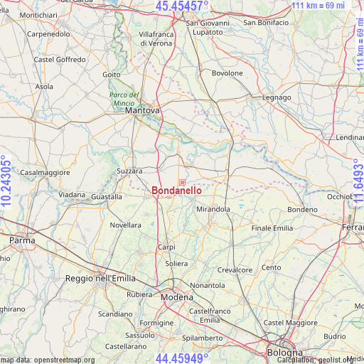
Bondanello GPS coordinates[2]
44° 57' 33.084" North, 10° 56' 46.212" East
| Map corner | latitude | longitude |
|---|---|---|
| Upper-left | 45.45457°, | 10.24305° |
| Center: | 44.95919°, | 10.94617° |
| Lower-right: | 44.45949°, | 11.6493° |
| Map W x H: | 110.6×110.6 km | = 68.7×68.7mi |
| max Lat: | 47.04031° ⇑40.9% North |
| Bondanello: | 44.95919° |
| min Lat: | ⇓59.1% South 35.50142° |
| min Long | Bondanello | max Long |
| 6.69888° | 10.94617° | 18.48682° |
| W 42%⇐ | ⇒58% E |
Elevation
Elevation of Bondanello is 18 m = 59 ft, and this is 288.7 m = 947 ft below average elevation for this country.
| Max E: |
2085 m = 6841 ft | 90.1% |
| Avg. | 306.7 m = 1006 ft | |
| Bondanello | 18 m = 59 ft | |
Min E: |
-4 m = -13 ft | 9.9% |
See also: Italy elevation on elevation.city.
Geographical zone
Bondanello is located in North temperate zone (between Tropic of Cancer and the Arctic Circle). Distance of this Northern Tropic circle is 2393.1 km =1487 mi to South.| Distance of | km | miles | from Bondanello |
|---|---|---|---|
| North Pole | 5008.1 | 3111.9 | to North |
| Arctic Circle | 2402.2 | 1492.7 | to North |
| Tropic Cancer | 2393.1 | 1487 | to South |
| Equator | 4999 | 3106.2 | to South |


Nearby cities:
15 places around Bondanello: (largest is in red/bold)
• Bondeno
7.2 km =4.5 mi,  248°
248°
• Concordia sulla Secchia
6.1 km =3.8 mi,  147°
147°
• Fossa
7.3 km =4.5 mi,  123°
123°
• Gonzaga
10 km =6.2 mi,  265°
265°
• Moglia
3.6 km =2.2 mi,  223°
223°
• Novi di Modena
8.5 km =5.3 mi,  205°
205°
• Pegognaga
7.9 km =4.9 mi,  300°
300°
• Quistello
6.2 km =3.9 mi,  28°
28°
• Rolo
10.7 km =6.6 mi, 219°
• San Benedetto Po
9.7 km =6 mi,  354°
354°
• San Giacomo delle Segnate
7.1 km =4.4 mi,  76°
76°
• San Giovanni del Dosso
10.6 km =6.6 mi,  85°
85°
• San Possidonio
9.9 km =6.2 mi,  163°
163°
• Schivenoglia
10.7 km =6.6 mi,  68°
68°
• Vallalta
5.1 km =3.2 mi,  110°
110°
Sources, notices
• [Note1] Compared only with cities in Italy existing in our database
• [Src1] Map data: © OpenStreetMap contributors (CC-BY-SA)
• [Src2] Other city data from geonames.org with taken over terms of usage.
• [Src3] Geographical zone / Annual Mean Temperature by Robert A. Rohde @ Wikipedia
