San Clemente geodata
San Clemente (Campania) is a seat of a third-order administrative division; located in Italy in Europe/Rome (GMT+2) time zone. With population of 883 people, there are 7252 cities with bigger population in this country. Compared to other cities in Italy, 75.8% of cities are located further ↑North; 77.9% of cities are located further ←West and 67.4% of cities have lower elevation than San Clemente. Note1


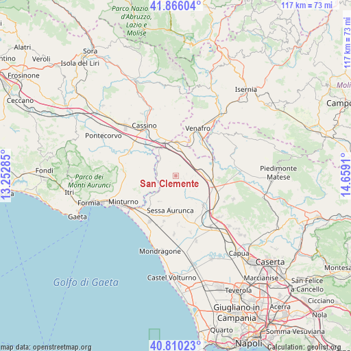
San Clemente GPS coordinates[2]
41° 20' 24.972" North, 13° 57' 21.492" East
| Map corner | latitude | longitude |
|---|---|---|
| Upper-left | 41.86604°, | 13.25285° |
| Center: | 41.34027°, | 13.95597° |
| Lower-right: | 40.81023°, | 14.6591° |
| Map W x H: | 117.4×117.4 km | = 72.9×72.9mi |
| max Lat: | 47.04031° ⇑75.8% North |
| San Clemente: | 41.34027° |
| min Lat: | ⇓24.2% South 35.50142° |
| min Long | San Clemente | max Long |
| 6.69888° | 13.95597° | 18.48682° |
| W 77.9%⇐ | ⇒22.1% E |
Elevation
Elevation of San Clemente is 367 m = 1204 ft, and this is 60.3 m = 198 ft above average elevation for this country.
| Max E: |
2085 m = 6841 ft | 32.6% |
| San Clemente | 367 m 1204 ft | |
| Avg. | 306.7 m = 1006 ft | |
Min E: |
-4 m = -13 ft | 67.4% |
See also: Italy elevation on elevation.city.
Geographical zone
San Clemente is located in North temperate zone (between Tropic of Cancer and the Arctic Circle). Distance of this Northern Tropic circle is 1990.7 km =1237 mi to South.| Distance of | km | miles | from San Clemente |
|---|---|---|---|
| North Pole | 5410.5 | 3361.9 | to North |
| Arctic Circle | 2804.6 | 1742.7 | to North |
| Tropic Cancer | 1990.7 | 1237 | to South |
| Equator | 4596.6 | 2856.2 | to South |


Nearby cities:
15 places around San Clemente: (largest is in red/bold)
• Bivio Mortola
7.9 km =4.9 mi,  321°
321°
• Casi
11.3 km =7 mi,  142°
142°
• Conca della Campania
3.1 km =1.9 mi,  107°
107°
• Forme di Suio-San Cataldo
9.7 km =6 mi,  238°
238°
• Galluccio
1.4 km =0.9 mi,  352°
352°
• Grottola
7.6 km =4.7 mi, 109°
• Lauro
10.1 km =6.3 mi,  212°
212°
• Marzano Appio
7.8 km =4.8 mi, 108°
• Mignano Monte Lungo
7.7 km =4.8 mi,  18°
18°
• Roccamonfina
6.2 km =3.9 mi,  162°
162°
• San Carlo
4.6 km =2.9 mi,  224°
224°
• Sant'Ambrogio sul Garigliano
9.4 km =5.8 mi,  309°
309°
• Sant'Andrea del Garigliano
10 km =6.2 mi,  288°
288°
• Santa Lucia
11.1 km =6.9 mi, 111°
• Tora
5.7 km =3.5 mi,  90°
90°
Sources, notices
• [Note1] Compared only with cities in Italy existing in our database
• [Src1] Map data: © OpenStreetMap contributors (CC-BY-SA)
• [Src2] Other city data from geonames.org with taken over terms of usage.
• [Src3] Geographical zone / Annual Mean Temperature by Robert A. Rohde @ Wikipedia
