Tora geodata
Tora (Campania) is a seat of a third-order administrative division; located in Italy in Europe/Rome (GMT+2) time zone. With population of 286 people, there are 10731 cities with bigger population in this country. Compared to other cities in Italy, 75.9% of cities are located further ↑North; 78.3% of cities are located further ←West and 61.6% of cities have lower elevation than Tora. Note1
Administrative division(s):
- Level 1: Campania
- Level 2: Provincia di Caserta
- Level 3: Tora e Piccilli


Tora GPS coordinates[2]
41° 20' 23.532" North, 14° 1' 26.364" East
| Map corner | latitude | longitude |
|---|---|---|
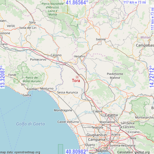
| Upper-left | 41.86564°, | 13.32087° |
| Center: | 41.33987°, | 14.02399° |
| Lower-right: | 40.80982°, | 14.72712° |
| Map W x H: | 117.4×117.4 km | = 72.9×72.9mi |
| max Lat: | 47.04031° ⇑75.9% North |
| Tora: | 41.33987° |
| min Lat: | ⇓24.1% South 35.50142° |
| min Long | Tora | max Long |
| 6.69888° | 14.02399° | 18.48682° |
| W 78.3%⇐ | ⇒21.7% E |
Elevation
Elevation of Tora is 312 m = 1024 ft, and this is 5.3 m = 17 ft above average elevation for this country.
| Max E: |
2085 m = 6841 ft | 38.4% |
| Tora | 312 m 1024 ft | |
| Avg. | 306.7 m = 1006 ft | |
Min E: |
-4 m = -13 ft | 61.6% |
See also: Italy elevation on elevation.city.
Geographical zone
Tora is located in North temperate zone (between Tropic of Cancer and the Arctic Circle). Distance of this Northern Tropic circle is 1990.6 km =1236.9 mi to South.| Distance of | km | miles | from Tora |
|---|---|---|---|
| North Pole | 5410.5 | 3361.9 | to North |
| Arctic Circle | 2804.6 | 1742.7 | to North |
| Tropic Cancer | 1990.6 | 1236.9 | to South |
| Equator | 4596.6 | 2856.2 | to South |


Nearby cities:
15 places around Tora: (largest is in red/bold)
• Caianello
6.4 km =4 mi,  127°
127°
• Casi
9.1 km =5.7 mi,  172°
172°
• Conca della Campania
2.9 km =1.8 mi,  251°
251°
• Galluccio
6 km =3.7 mi,  283°
283°
• Grottola
2.9 km =1.8 mi,  150°
150°
• Marzanello
8.2 km =5.1 mi,  110°
110°
• Marzano Appio
3 km =1.9 mi,  144°
144°
• Mignano Monte Lungo
8 km =5 mi,  336°
336°
• Montano
7.5 km =4.7 mi,  119°
119°
• Presenzano
7.1 km =4.4 mi,  52°
52°
• Roccamonfina
7 km =4.3 mi,  212°
212°
• San Carlo
9.4 km =5.8 mi, 249°
• San Clemente
5.7 km =3.5 mi,  270°
270°
• Santa Lucia
6.1 km =3.8 mi, 130°
• Vairano-Patenora
8.9 km =5.5 mi,  92°
92°
Sources, notices
• [Note1] Compared only with cities in Italy existing in our database
• [Src1] Map data: © OpenStreetMap contributors (CC-BY-SA)
• [Src2] Other city data from geonames.org with taken over terms of usage.
• [Src3] Geographical zone / Annual Mean Temperature by Robert A. Rohde @ Wikipedia
