Grottola geodata
Grottola (Campania) is a seat of a third-order administrative division; located in Italy in Europe/Rome (GMT+2) time zone. With population of 995 people, there are 6689 cities with bigger population in this country. Compared to other cities in Italy, 76% of cities are located further ↑North; 78.5% of cities are located further ←West and 62% of cities have lower elevation than Grottola. Note1


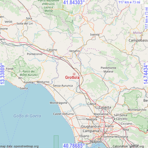
Grottola GPS coordinates[2]
41° 19' 1.488" North, 14° 2' 28.356" East
| Map corner | latitude | longitude |
|---|---|---|
| Upper-left | 41.84303°, | 13.33809° |
| Center: | 41.31708°, | 14.04121° |
| Lower-right: | 40.78685°, | 14.74434° |
| Map W x H: | 117.4×117.4 km | = 72.9×72.9mi |
| max Lat: | 47.04031° ⇑76% North |
| Grottola: | 41.31708° |
| min Lat: | ⇓24% South 35.50142° |
| min Long | Grottola | max Long |
| 6.69888° | 14.04121° | 18.48682° |
| W 78.5%⇐ | ⇒21.5% E |
Elevation
Elevation of Grottola is 315 m = 1033 ft, and this is 8.3 m = 27 ft above average elevation for this country.
| Max E: |
2085 m = 6841 ft | 38% |
| Grottola | 315 m 1033 ft | |
| Avg. | 306.7 m = 1006 ft | |
Min E: |
-4 m = -13 ft | 62% |
See also: Italy elevation on elevation.city.
Geographical zone
Grottola is located in North temperate zone (between Tropic of Cancer and the Arctic Circle). Distance of this Northern Tropic circle is 1988.1 km =1235.3 mi to South.| Distance of | km | miles | from Grottola |
|---|---|---|---|
| North Pole | 5413 | 3363.5 | to North |
| Arctic Circle | 2807.1 | 1744.3 | to North |
| Tropic Cancer | 1988.1 | 1235.3 | to South |
| Equator | 4594 | 2854.6 | to South |


Nearby cities:
15 places around Grottola: (largest is in red/bold)
• Caianello
3.9 km =2.4 mi,  109°
109°
• Casi
6.5 km =4 mi,  182°
182°
• Conca della Campania
4.5 km =2.8 mi,  291°
291°
• Galluccio
8.3 km =5.2 mi,  298°
298°
• Marzanello
6.3 km =3.9 mi,  92°
92°
• Marzano Appio
0.3 km =0.2 mi,  77°
77°
• Montano
5.2 km =3.2 mi,  102°
102°
• Presenzano
8 km =5 mi,  31°
31°
• Roccamonfina
6.2 km =3.9 mi,  237°
237°
• San Clemente
7.6 km =4.7 mi, 289°
• Santa Lucia
3.5 km =2.2 mi, 114°
• Scalo Ferroviario
9.8 km =6.1 mi,  163°
163°
• Teano
7.6 km =4.7 mi, 163°
• Tora
2.9 km =1.8 mi,  330°
330°
• Vairano-Patenora
7.8 km =4.8 mi,  73°
73°
Sources, notices
• [Note1] Compared only with cities in Italy existing in our database
• [Src1] Map data: © OpenStreetMap contributors (CC-BY-SA)
• [Src2] Other city data from geonames.org with taken over terms of usage.
• [Src3] Geographical zone / Annual Mean Temperature by Robert A. Rohde @ Wikipedia
