San Chirico Raparo geodata
San Chirico Raparo (Basilicate) is a seat of a third-order administrative division; located in Italy in Europe/Rome (GMT+2) time zone. With population of 1,101 people, there are 6294 cities with bigger population in this country. Compared to other cities in Italy, 86.4% of cities are located further ↑North; 93.3% of cities are located further ←West and 94% of cities have lower elevation than San Chirico Raparo. Note1
Administrative division(s):
- Level 1: Basilicate
- Level 2: Provincia di Potenza
- Level 3: San Chirico Raparo


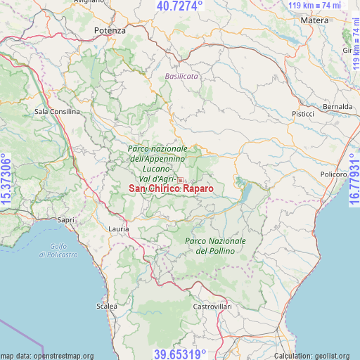
San Chirico Raparo GPS coordinates[2]
40° 11' 32.712" North, 16° 4' 34.248" East
| Map corner | latitude | longitude |
|---|---|---|
| Upper-left | 40.7274°, | 15.37306° |
| Center: | 40.19242°, | 16.07618° |
| Lower-right: | 39.65319°, | 16.77931° |
| Map W x H: | 119.4×119.4 km | = 74.2×74.2mi |
| max Lat: | 47.04031° ⇑86.4% North |
| San Chirico Raparo: | 40.19242° |
| min Lat: | ⇓13.6% South 35.50142° |
| min Long | San Chirico Rap | max Long |
| 6.69888° | 16.07618° | 18.48682° |
| W 93.3%⇐ | ⇒6.7% E |
Elevation
Elevation of San Chirico Raparo is 837 m = 2746 ft, and this is 530.3 m = 1740 ft above average elevation for this country.
| Max E: |
2085 m = 6841 ft | 6% |
| San Chirico Raparo | 837 m 2746 ft | |
| Avg. | 306.7 m = 1006 ft | |
Min E: |
-4 m = -13 ft | 94% |
See also: Italy elevation on elevation.city.
Geographical zone
San Chirico Raparo is located in North temperate zone (between Tropic of Cancer and the Arctic Circle). Distance of this Northern Tropic circle is 1863.1 km =1157.7 mi to South.| Distance of | km | miles | from San Chirico Raparo |
|---|---|---|---|
| North Pole | 5538.1 | 3441.2 | to North |
| Arctic Circle | 2932.2 | 1822 | to North |
| Tropic Cancer | 1863.1 | 1157.7 | to South |
| Equator | 4469 | 2776.9 | to South |


Nearby cities:
15 places around San Chirico Raparo: (largest is in red/bold)
• Armento
12.7 km =7.9 mi,  355°
355°
• Calvera
7.5 km =4.7 mi,  130°
130°
• Carbone
5.7 km =3.5 mi,  169°
169°
• Castelsaraceno
7.8 km =4.8 mi,  244°
244°
• Castronuovo di Sant'Andrea
9.3 km =5.8 mi,  92°
92°
• Episcopia
13.2 km =8.2 mi, 171°
• Fardella
11.8 km =7.3 mi,  137°
137°
• Gallicchio
12.2 km =7.6 mi,  24°
24°
• Latronico
12.8 km =8 mi,  206°
206°
• Missanello
12.7 km =7.9 mi,  37°
37°
• Montemurro
13.7 km =8.5 mi,  328°
328°
• Roccanova
11.1 km =6.9 mi,  78°
78°
• San Martino d'Agri
5.6 km =3.5 mi,  338°
338°
• Spinoso
12.6 km =7.8 mi,  312°
312°
• Teana
9.9 km =6.2 mi, 138°
Sources, notices
• [Note1] Compared only with cities in Italy existing in our database
• [Src1] Map data: © OpenStreetMap contributors (CC-BY-SA)
• [Src2] Other city data from geonames.org with taken over terms of usage.
• [Src3] Geographical zone / Annual Mean Temperature by Robert A. Rohde @ Wikipedia
