Missanello geodata
Missanello (Basilicate) is a seat of a third-order administrative division; located in Italy in Europe/Rome (GMT+2) time zone. With population of 523 people, there are 9703 cities with bigger population in this country. Compared to other cities in Italy, 85.7% of cities are located further ↑North; 94.1% of cities are located further ←West and 85.6% of cities have lower elevation than Missanello. Note1


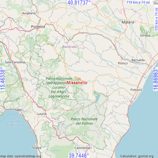
Missanello GPS coordinates[2]
40° 16' 59.196" North, 16° 9' 59.4" East
| Map corner | latitude | longitude |
|---|---|---|
| Upper-left | 40.81737°, | 15.46338° |
| Center: | 40.28311°, | 16.1665° |
| Lower-right: | 39.7446°, | 16.86963° |
| Map W x H: | 119.3×119.3 km | = 74.1×74.1mi |
| max Lat: | 47.04031° ⇑85.7% North |
| Missanello: | 40.28311° |
| min Lat: | ⇓14.3% South 35.50142° |
| min Long | Missanello | max Long |
| 6.69888° | 16.1665° | 18.48682° |
| W 94.1%⇐ | ⇒5.9% E |
Elevation
Elevation of Missanello is 623 m = 2044 ft, and this is 316.3 m = 1038 ft above average elevation for this country.
| Max E: |
2085 m = 6841 ft | 14.4% |
| Missanello | 623 m 2044 ft | |
| Avg. | 306.7 m = 1006 ft | |
Min E: |
-4 m = -13 ft | 85.6% |
See also: Italy elevation on elevation.city.
Geographical zone
Missanello is located in North temperate zone (between Tropic of Cancer and the Arctic Circle). Distance of this Northern Tropic circle is 1873.1 km =1163.9 mi to South.| Distance of | km | miles | from Missanello |
|---|---|---|---|
| North Pole | 5528 | 3434.9 | to North |
| Arctic Circle | 2922.1 | 1815.7 | to North |
| Tropic Cancer | 1873.1 | 1163.9 | to South |
| Equator | 4479.1 | 2783.2 | to South |


Nearby cities:
15 places around Missanello: (largest is in red/bold)
• Aliano
6.4 km =4 mi,  57°
57°
• Armento
9 km =5.6 mi,  286°
286°
• Calvera
15.1 km =9.4 mi,  187°
187°
• Castronuovo di Sant'Andrea
10.6 km =6.6 mi,  171°
171°
• Cirigliano
12.3 km =7.6 mi,  2°
2°
• Gallicchio
2.8 km =1.7 mi, 291°
• Gorgoglione
12.6 km =7.8 mi,  351°
351°
• Guardia Perticara
10.5 km =6.5 mi,  326°
326°
• Montemurro
14.9 km =9.3 mi,  276°
276°
• Roccanova
8.5 km =5.3 mi,  157°
157°
• San Brancato
8.1 km =5 mi,  109°
109°
• San Chirico Raparo
12.7 km =7.9 mi,  217°
217°
• San Martino d'Agri
10.9 km =6.8 mi,  243°
243°
• Sant'Arcangelo
9.6 km =6 mi, 113°
• Stigliano
14.3 km =8.9 mi,  22°
22°
Sources, notices
• [Note1] Compared only with cities in Italy existing in our database
• [Src1] Map data: © OpenStreetMap contributors (CC-BY-SA)
• [Src2] Other city data from geonames.org with taken over terms of usage.
• [Src3] Geographical zone / Annual Mean Temperature by Robert A. Rohde @ Wikipedia
