Roccanova geodata
Roccanova (Basilicate) is a seat of a third-order administrative division; located in Italy in Europe/Rome (GMT+2) time zone. With population of 1,142 people, there are 6145 cities with bigger population in this country. Compared to other cities in Italy, 86.3% of cities are located further ↑North; 94.4% of cities are located further ←West and 87.7% of cities have lower elevation than Roccanova. Note1


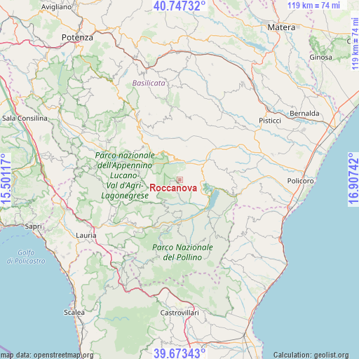
Roccanova GPS coordinates[2]
40° 12' 45" North, 16° 12' 15.444" East
| Map corner | latitude | longitude |
|---|---|---|
| Upper-left | 40.74732°, | 15.50117° |
| Center: | 40.2125°, | 16.20429° |
| Lower-right: | 39.67343°, | 16.90742° |
| Map W x H: | 119.4×119.4 km | = 74.2×74.2mi |
| max Lat: | 47.04031° ⇑86.3% North |
| Roccanova: | 40.2125° |
| min Lat: | ⇓13.7% South 35.50142° |
| min Long | Roccanova | max Long |
| 6.69888° | 16.20429° | 18.48682° |
| W 94.4%⇐ | ⇒5.6% E |
Elevation
Elevation of Roccanova is 667 m = 2188 ft, and this is 360.3 m = 1182 ft above average elevation for this country.
| Max E: |
2085 m = 6841 ft | 12.3% |
| Roccanova | 667 m 2188 ft | |
| Avg. | 306.7 m = 1006 ft | |
Min E: |
-4 m = -13 ft | 87.7% |
See also: Italy elevation on elevation.city.
Geographical zone
Roccanova is located in North temperate zone (between Tropic of Cancer and the Arctic Circle). Distance of this Northern Tropic circle is 1865.3 km =1159 mi to South.| Distance of | km | miles | from Roccanova |
|---|---|---|---|
| North Pole | 5535.9 | 3439.8 | to North |
| Arctic Circle | 2930 | 1820.6 | to North |
| Tropic Cancer | 1865.3 | 1159 | to South |
| Equator | 4471.2 | 2778.3 | to South |


Nearby cities:
15 places around Roccanova: (largest is in red/bold)
• Aliano
11.4 km =7.1 mi,  10°
10°
• Calvera
8.8 km =5.5 mi,  216°
216°
• Carbone
12.6 km =7.8 mi,  231°
231°
• Castronuovo di Sant'Andrea
3.1 km =1.9 mi,  211°
211°
• Chiaromonte
10 km =6.2 mi,  175°
175°
• Fardella
11.4 km =7.1 mi,  194°
194°
• Francavilla in Sinni
14.6 km =9.1 mi, 180°
• Gallicchio
10.6 km =6.6 mi,  326°
326°
• Missanello
8.5 km =5.3 mi,  337°
337°
• San Brancato
6.8 km =4.2 mi,  41°
41°
• San Chirico Raparo
11.1 km =6.9 mi,  258°
258°
• San Martino d'Agri
13.2 km =8.2 mi,  282°
282°
• Sant'Arcangelo
6.9 km =4.3 mi,  54°
54°
• Senise
10.3 km =6.4 mi,  135°
135°
• Teana
10.6 km =6.6 mi,  204°
204°
Sources, notices
• [Note1] Compared only with cities in Italy existing in our database
• [Src1] Map data: © OpenStreetMap contributors (CC-BY-SA)
• [Src2] Other city data from geonames.org with taken over terms of usage.
• [Src3] Geographical zone / Annual Mean Temperature by Robert A. Rohde @ Wikipedia
