Calvera geodata
Calvera (Basilicate) is a seat of a third-order administrative division; located in Italy in Europe/Rome (GMT+2) time zone. With population of 319 people, there are 10599 cities with bigger population in this country. Compared to other cities in Italy, 86.7% of cities are located further ↑North; 93.9% of cities are located further ←West and 85.1% of cities have lower elevation than Calvera. Note1


Calvera GPS coordinates[2]
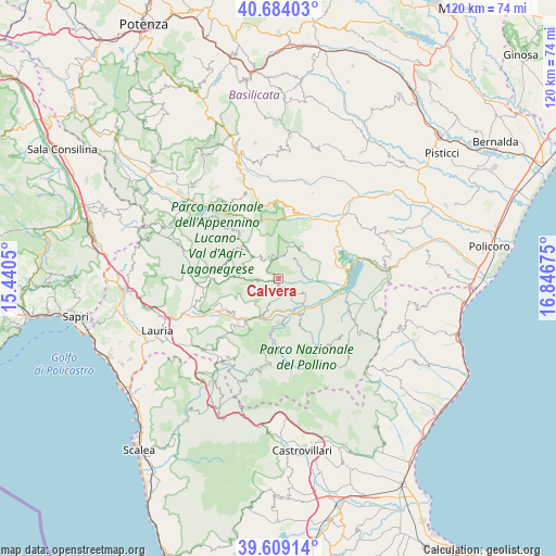
40° 8' 55.356" North, 16° 8' 37.032" East
| Map corner | latitude | longitude |
|---|---|---|
| Upper-left | 40.68403°, | 15.4405° |
| Center: | 40.14871°, | 16.14362° |
| Lower-right: | 39.60914°, | 16.84675° |
| Map W x H: | 119.5×119.5 km | = 74.3×74.3mi |
| max Lat: | 47.04031° ⇑86.7% North |
| Calvera: | 40.14871° |
| min Lat: | ⇓13.3% South 35.50142° |
| min Long | Calvera | max Long |
| 6.69888° | 16.14362° | 18.48682° |
| W 93.9%⇐ | ⇒6.1% E |
Elevation
Elevation of Calvera is 616 m = 2021 ft, and this is 309.3 m = 1015 ft above average elevation for this country.
| Max E: |
2085 m = 6841 ft | 14.9% |
| Calvera | 616 m 2021 ft | |
| Avg. | 306.7 m = 1006 ft | |
Min E: |
-4 m = -13 ft | 85.1% |
See also: Italy elevation on elevation.city.
Geographical zone
Calvera is located in North temperate zone (between Tropic of Cancer and the Arctic Circle). Distance of this Northern Tropic circle is 1858.2 km =1154.6 mi to South.| Distance of | km | miles | from Calvera |
|---|---|---|---|
| North Pole | 5542.9 | 3444.2 | to North |
| Arctic Circle | 2937.1 | 1825 | to North |
| Tropic Cancer | 1858.2 | 1154.6 | to South |
| Equator | 4464.1 | 2773.9 | to South |


Nearby cities:
15 places around Calvera: (largest is in red/bold)
• Carbone
4.7 km =2.9 mi,  261°
261°
• Castelsaraceno
12.9 km =8 mi,  276°
276°
• Castronuovo di Sant'Andrea
5.7 km =3.5 mi,  38°
38°
• Chiaromonte
6.7 km =4.2 mi,  115°
115°
• Episcopia
9.1 km =5.7 mi,  205°
205°
• Fardella
4.5 km =2.8 mi,  150°
150°
• Francavilla in Sinni
9.1 km =5.7 mi, 145°
• Latronico
13.2 km =8.2 mi,  239°
239°
• Magnano
12.9 km =8 mi,  215°
215°
• Roccanova
8.8 km =5.5 mi, 36°
• San Chirico Raparo
7.5 km =4.7 mi,  310°
310°
• San Martino d'Agri
12.7 km =7.9 mi,  322°
322°
• San Severino Lucano
14.3 km =8.9 mi,  181°
181°
• Senise
12.3 km =7.6 mi,  91°
91°
• Teana
2.7 km =1.7 mi,  162°
162°
Sources, notices
• [Note1] Compared only with cities in Italy existing in our database
• [Src1] Map data: © OpenStreetMap contributors (CC-BY-SA)
• [Src2] Other city data from geonames.org with taken over terms of usage.
• [Src3] Geographical zone / Annual Mean Temperature by Robert A. Rohde @ Wikipedia
