Allerona geodata
Allerona (Umbria) is a seat of a third-order administrative division; located in Italy in Europe/Rome (GMT+2) time zone. With population of 388 people, there are 10328 cities with bigger population in this country. Compared to other cities in Italy, 64.6% of cities are located further ↑North; 55.5% of cities are located further ←West and 74.8% of cities have lower elevation than Allerona. Note1


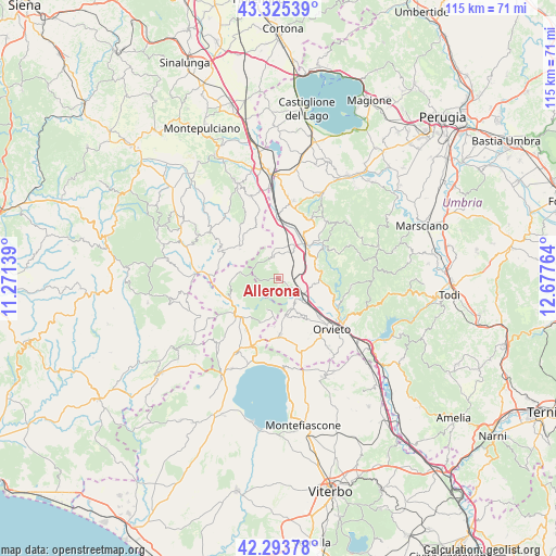
Allerona GPS coordinates[2]
42° 48' 42.264" North, 11° 58' 28.236" East
| Map corner | latitude | longitude |
|---|---|---|
| Upper-left | 43.32539°, | 11.27139° |
| Center: | 42.81174°, | 11.97451° |
| Lower-right: | 42.29378°, | 12.67764° |
| Map W x H: | 114.7×114.7 km | = 71.3×71.3mi |
| max Lat: | 47.04031° ⇑64.6% North |
| Allerona: | 42.81174° |
| min Lat: | ⇓35.4% South 35.50142° |
| min Long | Allerona | max Long |
| 6.69888° | 11.97451° | 18.48682° |
| W 55.5%⇐ | ⇒44.5% E |
Elevation
Elevation of Allerona is 449 m = 1473 ft, and this is 142.3 m = 467 ft above average elevation for this country.
| Max E: |
2085 m = 6841 ft | 25.2% |
| Allerona | 449 m 1473 ft | |
| Avg. | 306.7 m = 1006 ft | |
Min E: |
-4 m = -13 ft | 74.8% |
See also: Italy elevation on elevation.city.
Geographical zone
Allerona is located in North temperate zone (between Tropic of Cancer and the Arctic Circle). Distance of this Northern Tropic circle is 2154.3 km =1338.6 mi to South.| Distance of | km | miles | from Allerona |
|---|---|---|---|
| North Pole | 5246.8 | 3260.2 | to North |
| Arctic Circle | 2641 | 1641 | to North |
| Tropic Cancer | 2154.3 | 1338.6 | to South |
| Equator | 4760.2 | 2957.9 | to South |


Nearby cities:
15 places around Allerona: (largest is in red/bold)
• Acquapendente
11.6 km =7.2 mi,  228°
228°
• Castel Giorgio
11.7 km =7.3 mi,  178°
178°
• Castel Viscardo
6.8 km =4.2 mi,  161°
161°
• Fabro
7.6 km =4.7 mi,  26°
26°
• Fabro Scalo
9.2 km =5.7 mi,  39°
39°
• Ficulle
7.9 km =4.9 mi,  73°
73°
• Monterubiaglio
6.1 km =3.8 mi,  145°
145°
• Parrano
12.6 km =7.8 mi,  61°
61°
• Pianlungo
6 km =3.7 mi,  123°
123°
• Piazze
11.7 km =7.3 mi,  336°
336°
• Ponticelli
13.3 km =8.3 mi,  0°
0°
• Proceno
13.3 km =8.3 mi,  243°
243°
• San Casciano dei Bagni
10.3 km =6.4 mi,  309°
309°
• Santa Maria
10.4 km =6.5 mi, 29°
• Stazione di Allerona
5.9 km =3.7 mi, 119°
Sources, notices
• [Note1] Compared only with cities in Italy existing in our database
• [Src1] Map data: © OpenStreetMap contributors (CC-BY-SA)
• [Src2] Other city data from geonames.org with taken over terms of usage.
• [Src3] Geographical zone / Annual Mean Temperature by Robert A. Rohde @ Wikipedia
