Vedelago geodata
Vedelago (Veneto) is a seat of a third-order administrative division; located in Italy in Europe/Rome (GMT+2) time zone. With population of 3,939 people, there are 2426 cities with bigger population in this country. Compared to other cities in Italy, 80.6% of cities are located further ↓South; 56.1% of cities are located further ←West and 80.9% of cities have higher elevation than Vedelago. Note1


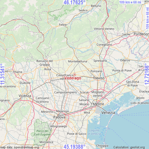
Vedelago GPS coordinates[2]
45° 41' 13.992" North, 12° 1' 6.708" East
| Map corner | latitude | longitude |
|---|---|---|
| Upper-left | 46.17625°, | 11.31541° |
| Center: | 45.68722°, | 12.01853° |
| Lower-right: | 45.19388°, | 12.72166° |
| Map W x H: | 109.2×109.2 km | = 67.9×67.9mi |
| max Lat: | 47.04031° ⇑19.4% North |
| Vedelago: | 45.68722° |
| min Lat: | ⇓80.6% South 35.50142° |
| min Long | Vedelago | max Long |
| 6.69888° | 12.01853° | 18.48682° |
| W 56.1%⇐ | ⇒43.9% E |
Elevation
Elevation of Vedelago is 46 m = 151 ft, and this is 260.7 m = 855 ft below average elevation for this country.
| Max E: |
2085 m = 6841 ft | 80.9% |
| Avg. | 306.7 m = 1006 ft | |
| Vedelago | 46 m = 151 ft | |
Min E: |
-4 m = -13 ft | 19.1% |
See also: Italy elevation on elevation.city.
Geographical zone
Vedelago is located in North temperate zone (between Tropic of Cancer and the Arctic Circle). Distance of this North polar circle is 2321.2 km =1442.3 mi to North.| Distance of | km | miles | from Vedelago |
|---|---|---|---|
| North Pole | 4927.1 | 3061.6 | to North |
| Arctic Circle | 2321.2 | 1442.3 | to North |
| Tropic Cancer | 2474 | 1537.3 | to South |
| Equator | 5079.9 | 3156.5 | to South |


Nearby cities:
15 places around Vedelago: (largest is in red/bold)
• Albaredo
2.3 km =1.4 mi,  194°
194°
• Barcon
3.9 km =2.4 mi,  353°
353°
• Carpenedo
3.3 km =2.1 mi,  113°
113°
• Casacorba
3.5 km =2.2 mi,  152°
152°
• Castelminio
5.3 km =3.3 mi,  207°
207°
• Cavasagra
3.9 km =2.4 mi,  134°
134°
• Fanzolo
3.5 km =2.2 mi,  321°
321°
• Fossalunga
2.7 km =1.7 mi,  79°
79°
• Istrana
6.5 km =4 mi,  100°
100°
• Ospedaletto
5.5 km =3.4 mi,  120°
120°
• Pezzan
6.1 km =3.8 mi, 83°
• Sala
6.2 km =3.9 mi,  73°
73°
• Salvatronda
3.5 km =2.2 mi,  245°
245°
• Torreselle
6.3 km =3.9 mi,  177°
177°
• Trevignano
6.7 km =4.2 mi,  34°
34°
Sources, notices
• [Note1] Compared only with cities in Italy existing in our database
• [Src1] Map data: © OpenStreetMap contributors (CC-BY-SA)
• [Src2] Other city data from geonames.org with taken over terms of usage.
• [Src3] Geographical zone / Annual Mean Temperature by Robert A. Rohde @ Wikipedia
