Torreselle geodata
Torreselle (Veneto) is a populated place; located in Italy in Europe/Rome (GMT+2) time zone. With population of 1,105 people, there are 6278 cities with bigger population in this country. Compared to other cities in Italy, 78.3% of cities are located further ↓South; 56.1% of cities are located further ←West and 86.4% of cities have higher elevation than Torreselle. Note1


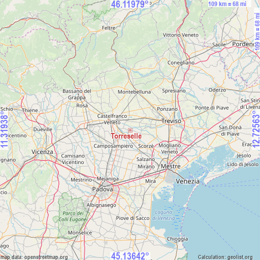
Torreselle GPS coordinates[2]
45° 37' 48.936" North, 12° 1' 21" East
| Map corner | latitude | longitude |
|---|---|---|
| Upper-left | 46.11979°, | 11.31938° |
| Center: | 45.63026°, | 12.0225° |
| Lower-right: | 45.13642°, | 12.72563° |
| Map W x H: | 109.3×109.3 km | = 67.9×67.9mi |
| max Lat: | 47.04031° ⇑21.7% North |
| Torreselle: | 45.63026° |
| min Lat: | ⇓78.3% South 35.50142° |
| min Long | Torreselle | max Long |
| 6.69888° | 12.0225° | 18.48682° |
| W 56.1%⇐ | ⇒43.9% E |
Elevation
Elevation of Torreselle is 27 m = 89 ft, and this is 279.7 m = 918 ft below average elevation for this country.
| Max E: |
2085 m = 6841 ft | 86.4% |
| Avg. | 306.7 m = 1006 ft | |
| Torreselle | 27 m = 89 ft | |
Min E: |
-4 m = -13 ft | 13.6% |
See also: Italy elevation on elevation.city.
Geographical zone
Torreselle is located in North temperate zone (between Tropic of Cancer and the Arctic Circle). Distance of this North polar circle is 2327.6 km =1446.3 mi to North.| Distance of | km | miles | from Torreselle |
|---|---|---|---|
| North Pole | 4933.5 | 3065.5 | to North |
| Arctic Circle | 2327.6 | 1446.3 | to North |
| Tropic Cancer | 2467.7 | 1533.4 | to South |
| Equator | 5073.6 | 3152.6 | to South |


Nearby cities:
15 places around Torreselle: (largest is in red/bold)
• Albaredo
4.2 km =2.6 mi,  347°
347°
• Badoere
4.9 km =3 mi,  84°
84°
• Carpenedo
5.7 km =3.5 mi,  28°
28°
• Casacorba
3.5 km =2.2 mi,  21°
21°
• Castelminio
3.2 km =2 mi,  300°
300°
• Cavasagra
4.4 km =2.7 mi,  35°
35°
• Levada
2.7 km =1.7 mi,  103°
103°
• Ospedaletto
5.6 km =3.5 mi,  51°
51°
• Piombino Dese
3.2 km =2 mi,  223°
223°
• Resana
5.3 km =3.3 mi,  276°
276°
• Ronchi
4.4 km =2.7 mi,  203°
203°
• Salvatronda
6 km =3.7 mi,  324°
324°
• Sant'Ambrogio
5.1 km =3.2 mi,  121°
121°
• Scandolara
6.3 km =3.9 mi,  106°
106°
• Trebaseleghe
4.5 km =2.8 mi,  158°
158°
Sources, notices
• [Note1] Compared only with cities in Italy existing in our database
• [Src1] Map data: © OpenStreetMap contributors (CC-BY-SA)
• [Src2] Other city data from geonames.org with taken over terms of usage.
• [Src3] Geographical zone / Annual Mean Temperature by Robert A. Rohde @ Wikipedia
