Rovato geodata
Rovato (Lombardy) is a seat of a third-order administrative division; located in Italy in Europe/Rome (GMT+2) time zone. With population of 12,239 people, there are 759 cities with bigger population in this country. Compared to other cities in Italy, 75.7% of cities are located further ↓South; 67.8% of cities are located further →East and 59.2% of cities have higher elevation than Rovato. Note1


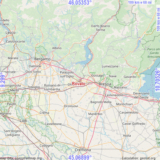
Rovato GPS coordinates[2]
45° 33' 48.312" North, 10° 0' 7.668" East
| Map corner | latitude | longitude |
|---|---|---|
| Upper-left | 46.05353°, | 9.299° |
| Center: | 45.56342°, | 10.00213° |
| Lower-right: | 45.06899°, | 10.70526° |
| Map W x H: | 109.5×109.5 km | = 68×68mi |
| max Lat: | 47.04031° ⇑24.3% North |
| Rovato: | 45.56342° |
| min Lat: | ⇓75.7% South 35.50142° |
| min Long | Rovato | max Long |
| 6.69888° | 10.00213° | 18.48682° |
| W 32.2%⇐ | ⇒67.8% E |
Elevation
Elevation of Rovato is 169 m = 554 ft, and this is 137.7 m = 452 ft below average elevation for this country.
| Max E: |
2085 m = 6841 ft | 59.2% |
| Avg. | 306.7 m = 1006 ft | |
| Rovato | 169 m = 554 ft | |
Min E: |
-4 m = -13 ft | 40.8% |
See also: Italy elevation on elevation.city.
Geographical zone
Rovato is located in North temperate zone (between Tropic of Cancer and the Arctic Circle). Distance of this North polar circle is 2335 km =1450.9 mi to North.| Distance of | km | miles | from Rovato |
|---|---|---|---|
| North Pole | 4940.9 | 3070.1 | to North |
| Arctic Circle | 2335 | 1450.9 | to North |
| Tropic Cancer | 2460.3 | 1528.8 | to South |
| Equator | 5066.2 | 3148 | to South |


Nearby cities:
15 places around Rovato: (largest is in red/bold)
• Bornato
4.5 km =2.8 mi,  41°
41°
• Castrezzato
6 km =3.7 mi,  195°
195°
• Cazzago San Martino-Calino
2.8 km =1.7 mi, 35°
• Coccaglio
2.3 km =1.4 mi,  271°
271°
• Cologne
5 km =3.1 mi,  289°
289°
• Costa-Barco
3.6 km =2.2 mi,  52°
52°
• Duomo
3.8 km =2.4 mi,  156°
156°
• Erbusco
4.6 km =2.9 mi,  329°
329°
• Lodetto
2.7 km =1.7 mi,  120°
120°
• Monterotondo
6 km =3.7 mi,  32°
32°
• Ospitaletto
5.9 km =3.7 mi,  102°
102°
• Sant'Andrea
2.4 km =1.5 mi, 195°
• Segabiello
4.1 km =2.5 mi, 123°
• Torbiato
5.6 km =3.5 mi,  344°
344°
• Villa Pedergnano
2.5 km =1.6 mi,  345°
345°
Sources, notices
• [Note1] Compared only with cities in Italy existing in our database
• [Src1] Map data: © OpenStreetMap contributors (CC-BY-SA)
• [Src2] Other city data from geonames.org with taken over terms of usage.
• [Src3] Geographical zone / Annual Mean Temperature by Robert A. Rohde @ Wikipedia
