Cologne geodata
Cologne (Lombardy) is a seat of a third-order administrative division; located in Italy in Europe/Rome (GMT+2) time zone. With population of 7,032 people, there are 1394 cities with bigger population in this country. Compared to other cities in Italy, 76.2% of cities are located further ↓South; 68.4% of cities are located further →East and 58.7% of cities have higher elevation than Cologne. Note1


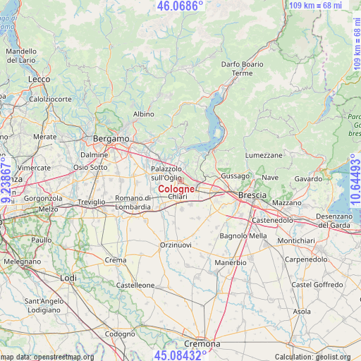
Cologne GPS coordinates[2]
45° 34' 43.032" North, 9° 56' 30.48" East
| Map corner | latitude | longitude |
|---|---|---|
| Upper-left | 46.0686°, | 9.23867° |
| Center: | 45.57862°, | 9.9418° |
| Lower-right: | 45.08432°, | 10.64493° |
| Map W x H: | 109.4×109.4 km | = 68×68mi |
| max Lat: | 47.04031° ⇑23.8% North |
| Cologne: | 45.57862° |
| min Lat: | ⇓76.2% South 35.50142° |
| min Long | Cologne | max Long |
| 6.69888° | 9.9418° | 18.48682° |
| W 31.6%⇐ | ⇒68.4% E |
Elevation
Elevation of Cologne is 174 m = 571 ft, and this is 132.7 m = 435 ft below average elevation for this country.
| Max E: |
2085 m = 6841 ft | 58.7% |
| Avg. | 306.7 m = 1006 ft | |
| Cologne | 174 m = 571 ft | |
Min E: |
-4 m = -13 ft | 41.3% |
See also: Italy elevation on elevation.city.
Geographical zone
Cologne is located in North temperate zone (between Tropic of Cancer and the Arctic Circle). Distance of this North polar circle is 2333.3 km =1449.8 mi to North.| Distance of | km | miles | from Cologne |
|---|---|---|---|
| North Pole | 4939.2 | 3069.1 | to North |
| Arctic Circle | 2333.3 | 1449.8 | to North |
| Tropic Cancer | 2461.9 | 1529.8 | to South |
| Equator | 5067.9 | 3149 | to South |


Nearby cities:
15 places around Cologne: (largest is in red/bold)
• Adro
4.9 km =3 mi,  18°
18°
• Capriolo
6.1 km =3.8 mi,  352°
352°
• Castelli Calepio
5.8 km =3.6 mi,  311°
311°
• Cazzago San Martino-Calino
6.4 km =4 mi,  84°
84°
• Chiari
4.7 km =2.9 mi,  194°
194°
• Coccaglio
2.9 km =1.8 mi,  124°
124°
• Corte Franca
6.8 km =4.2 mi,  32°
32°
• Erbusco
3.2 km =2 mi,  46°
46°
• Nigoline-Bonomelli
6.6 km =4.1 mi, 31°
• Palazzolo sull'Oglio
4.7 km =2.9 mi,  295°
295°
• Pontoglio
7 km =4.3 mi,  261°
261°
• Rovato
5 km =3.1 mi,  109°
109°
• Sant'Andrea
5.7 km =3.5 mi,  134°
134°
• Torbiato
4.9 km =3 mi,  41°
41°
• Villa Pedergnano
4.1 km =2.5 mi, 79°
Sources, notices
• [Note1] Compared only with cities in Italy existing in our database
• [Src1] Map data: © OpenStreetMap contributors (CC-BY-SA)
• [Src2] Other city data from geonames.org with taken over terms of usage.
• [Src3] Geographical zone / Annual Mean Temperature by Robert A. Rohde @ Wikipedia
