Ripapersico geodata
Ripapersico (Emilia-Romagna) is a populated place; located in Italy in Europe/Rome (GMT+2) time zone. With population of 668 people, there are 8500 cities with bigger population in this country. Compared to other cities in Italy, 54% of cities are located further ↓South; 52.9% of cities are located further ←West and 99.4% of cities have higher elevation than Ripapersico. Note1
Administrative division(s):
- Level 1: Emilia-Romagna
- Level 2: Provincia di Ferrara
- Level 3: Portomaggiore


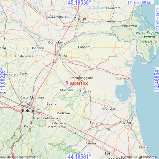
Ripapersico GPS coordinates[2]
44° 41' 15.54" North, 11° 47' 7.476" East
| Map corner | latitude | longitude |
|---|---|---|
| Upper-left | 45.18538°, | 11.08229° |
| Center: | 44.68765°, | 11.78541° |
| Lower-right: | 44.18561°, | 12.48854° |
| Map W x H: | 111.2×111.2 km | = 69.1×69.1mi |
| max Lat: | 47.04031° ⇑46% North |
| Ripapersico: | 44.68765° |
| min Lat: | ⇓54% South 35.50142° |
| min Long | Ripapersico | max Long |
| 6.69888° | 11.78541° | 18.48682° |
| W 52.9%⇐ | ⇒47.1% E |
Elevation
Elevation of Ripapersico is 1 m = 3 ft, and this is 305.7 m = 1003 ft below average elevation for this country.
| Max E: |
2085 m = 6841 ft | 99.4% |
| Avg. | 306.7 m = 1006 ft | |
| Ripapersico | 1 m = 3 ft | |
Min E: |
-4 m = -13 ft | 0.6% |
See also: Italy elevation on elevation.city.
Geographical zone
Ripapersico is located in North temperate zone (between Tropic of Cancer and the Arctic Circle). Distance of this Northern Tropic circle is 2362.9 km =1468.2 mi to South.| Distance of | km | miles | from Ripapersico |
|---|---|---|---|
| North Pole | 5038.3 | 3130.7 | to North |
| Arctic Circle | 2432.4 | 1511.4 | to North |
| Tropic Cancer | 2362.9 | 1468.2 | to South |
| Equator | 4968.8 | 3087.5 | to South |


Nearby cities:
15 places around Ripapersico: (largest is in red/bold)
• Argenta
9.1 km =5.7 mi,  154°
154°
• Consandolo
3.6 km =2.2 mi,  192°
192°
• Dogato
10.6 km =6.6 mi,  50°
50°
• Gambulaga
6.3 km =3.9 mi,  3°
3°
• Marmorta
9.4 km =5.8 mi,  215°
215°
• Marrara
8.8 km =5.5 mi,  296°
296°
• Masi-Torello
12 km =7.5 mi,  6°
6°
• Molinella
12.2 km =7.6 mi,  230°
230°
• Monestirolo
9.3 km =5.8 mi, 304°
• Ospital Monacale
7.1 km =4.4 mi,  250°
250°
• Portomaggiore
2.1 km =1.3 mi,  57°
57°
• San Nicolò
6.4 km =4 mi,  290°
290°
• San Pietro Capofiume
11.6 km =7.2 mi, 249°
• Santa Maria Codifiume
10.9 km =6.8 mi,  256°
256°
• Voghiera
8 km =5 mi,  340°
340°
Sources, notices
• [Note1] Compared only with cities in Italy existing in our database
• [Src1] Map data: © OpenStreetMap contributors (CC-BY-SA)
• [Src2] Other city data from geonames.org with taken over terms of usage.
• [Src3] Geographical zone / Annual Mean Temperature by Robert A. Rohde @ Wikipedia
