Masi-Torello geodata
Masi-Torello (Emilia-Romagna) is a seat of a third-order administrative division; located in Italy in Europe/Rome (GMT+2) time zone. With population of 1,303 people, there are 5627 cities with bigger population in this country. Compared to other cities in Italy, 56.1% of cities are located further ↓South; 53.2% of cities are located further ←West and 97.8% of cities have higher elevation than Masi-Torello. Note1
Administrative division(s):
- Level 1: Emilia-Romagna
- Level 2: Provincia di Ferrara
- Level 3: Masi Torello


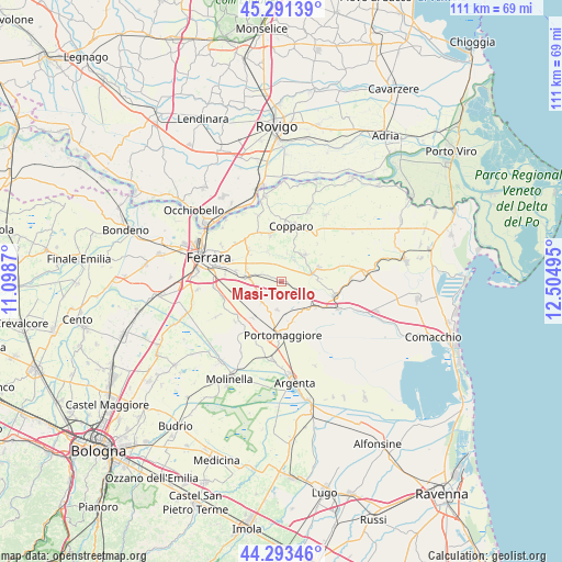
Masi-Torello GPS coordinates[2]
44° 47' 40.488" North, 11° 48' 6.552" East
| Map corner | latitude | longitude |
|---|---|---|
| Upper-left | 45.29139°, | 11.0987° |
| Center: | 44.79458°, | 11.80182° |
| Lower-right: | 44.29346°, | 12.50495° |
| Map W x H: | 111×111 km | = 69×69mi |
| max Lat: | 47.04031° ⇑43.9% North |
| Masi-Torello: | 44.79458° |
| min Lat: | ⇓56.1% South 35.50142° |
| min Long | Masi-Torello | max Long |
| 6.69888° | 11.80182° | 18.48682° |
| W 53.2%⇐ | ⇒46.8% E |
Elevation
Elevation of Masi-Torello is 4 m = 13 ft, and this is 302.7 m = 993 ft below average elevation for this country.
| Max E: |
2085 m = 6841 ft | 97.8% |
| Avg. | 306.7 m = 1006 ft | |
| Masi-Torello | 4 m = 13 ft | |
Min E: |
-4 m = -13 ft | 2.2% |
See also: Italy elevation on elevation.city.
Geographical zone
Masi-Torello is located in North temperate zone (between Tropic of Cancer and the Arctic Circle). Distance of this Northern Tropic circle is 2374.8 km =1475.6 mi to South.| Distance of | km | miles | from Masi-Torello |
|---|---|---|---|
| North Pole | 5026.4 | 3123.3 | to North |
| Arctic Circle | 2420.5 | 1504 | to North |
| Tropic Cancer | 2374.8 | 1475.6 | to South |
| Equator | 4980.7 | 3094.9 | to South |


Nearby cities:
15 places around Masi-Torello: (largest is in red/bold)
• Aguscello
11.3 km =7 mi,  276°
276°
• Baura
9.2 km =5.7 mi,  314°
314°
• Cona
7.6 km =4.7 mi, 279°
• Copparo
11 km =6.8 mi,  8°
8°
• Dogato
8.5 km =5.3 mi,  126°
126°
• Formignana
7 km =4.3 mi,  40°
40°
• Gambulaga
5.7 km =3.5 mi,  188°
188°
• La Saletta-Tamara
9.9 km =6.2 mi,  346°
346°
• Migliarino
10.7 km =6.6 mi,  104°
104°
• Monestirolo
11.1 km =6.9 mi,  233°
233°
• Portomaggiore
10.8 km =6.7 mi,  177°
177°
• Quartesana
5.1 km =3.2 mi, 282°
• Ripapersico
12 km =7.5 mi, 186°
• Tresigallo-Final di Rero
7.7 km =4.8 mi,  72°
72°
• Voghiera
5.9 km =3.7 mi,  222°
222°
Sources, notices
• [Note1] Compared only with cities in Italy existing in our database
• [Src1] Map data: © OpenStreetMap contributors (CC-BY-SA)
• [Src2] Other city data from geonames.org with taken over terms of usage.
• [Src3] Geographical zone / Annual Mean Temperature by Robert A. Rohde @ Wikipedia
