Voghiera geodata
Voghiera (Emilia-Romagna) is a seat of a third-order administrative division; located in Italy in Europe/Rome (GMT+2) time zone. With population of 1,158 people, there are 6090 cities with bigger population in this country. Compared to other cities in Italy, 55.4% of cities are located further ↓South; 52.5% of cities are located further ←West and 97.2% of cities have higher elevation than Voghiera. Note1


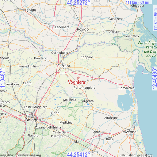
Voghiera GPS coordinates[2]
44° 45' 20.088" North, 11° 45' 6.552" East
| Map corner | latitude | longitude |
|---|---|---|
| Upper-left | 45.25272°, | 11.0487° |
| Center: | 44.75558°, | 11.75182° |
| Lower-right: | 44.25412°, | 12.45495° |
| Map W x H: | 111×111 km | = 69×69mi |
| max Lat: | 47.04031° ⇑44.6% North |
| Voghiera: | 44.75558° |
| min Lat: | ⇓55.4% South 35.50142° |
| min Long | Voghiera | max Long |
| 6.69888° | 11.75182° | 18.48682° |
| W 52.5%⇐ | ⇒47.5% E |
Elevation
Elevation of Voghiera is 5 m = 16 ft, and this is 301.7 m = 990 ft below average elevation for this country.
| Max E: |
2085 m = 6841 ft | 97.2% |
| Avg. | 306.7 m = 1006 ft | |
| Voghiera | 5 m = 16 ft | |
Min E: |
-4 m = -13 ft | 2.8% |
See also: Italy elevation on elevation.city.
Geographical zone
Voghiera is located in North temperate zone (between Tropic of Cancer and the Arctic Circle). Distance of this Northern Tropic circle is 2370.4 km =1472.9 mi to South.| Distance of | km | miles | from Voghiera |
|---|---|---|---|
| North Pole | 5030.7 | 3125.9 | to North |
| Arctic Circle | 2424.8 | 1506.7 | to North |
| Tropic Cancer | 2370.4 | 1472.9 | to South |
| Equator | 4976.4 | 3092.2 | to South |


Nearby cities:
15 places around Voghiera: (largest is in red/bold)
• Aguscello
9.2 km =5.7 mi,  308°
308°
• Cona
6.6 km =4.1 mi,  327°
327°
• Dogato
10.8 km =6.7 mi,  93°
93°
• Fossanova San Marco
10.4 km =6.5 mi,  291°
291°
• Gaibanella-Sant'Edigio
8.1 km =5 mi,  278°
278°
• Gambulaga
3.3 km =2.1 mi,  112°
112°
• Marrara
6.3 km =3.9 mi,  235°
235°
• Masi-Torello
5.9 km =3.7 mi,  42°
42°
• Monestirolo
5.5 km =3.4 mi,  245°
245°
• Ospital Monacale
10.7 km =6.6 mi,  202°
202°
• Portomaggiore
7.8 km =4.8 mi,  145°
145°
• Quartesana
5.6 km =3.5 mi,  349°
349°
• Ripapersico
8 km =5 mi,  160°
160°
• San Bartolomeo In Bosco
9.6 km =6 mi, 253°
• San Nicolò
6.3 km =3.9 mi,  212°
212°
Sources, notices
• [Note1] Compared only with cities in Italy existing in our database
• [Src1] Map data: © OpenStreetMap contributors (CC-BY-SA)
• [Src2] Other city data from geonames.org with taken over terms of usage.
• [Src3] Geographical zone / Annual Mean Temperature by Robert A. Rohde @ Wikipedia
