Monestirolo geodata
Monestirolo (Emilia-Romagna) is a populated place; located in Italy in Europe/Rome (GMT+2) time zone. With population of 549 people, there are 9458 cities with bigger population in this country. Compared to other cities in Italy, 55% of cities are located further ↓South; 51.7% of cities are located further ←West and 96.6% of cities have higher elevation than Monestirolo. Note1


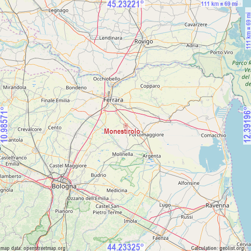
Monestirolo GPS coordinates[2]
44° 44' 5.604" North, 11° 41' 19.788" East
| Map corner | latitude | longitude |
|---|---|---|
| Upper-left | 45.23221°, | 10.98571° |
| Center: | 44.73489°, | 11.68883° |
| Lower-right: | 44.23325°, | 12.39196° |
| Map W x H: | 111.1×111.1 km | = 69×69mi |
| max Lat: | 47.04031° ⇑45% North |
| Monestirolo: | 44.73489° |
| min Lat: | ⇓55% South 35.50142° |
| min Long | Monestirolo | max Long |
| 6.69888° | 11.68883° | 18.48682° |
| W 51.7%⇐ | ⇒48.3% E |
Elevation
Elevation of Monestirolo is 6 m = 20 ft, and this is 300.7 m = 987 ft below average elevation for this country.
| Max E: |
2085 m = 6841 ft | 96.6% |
| Avg. | 306.7 m = 1006 ft | |
| Monestirolo | 6 m = 20 ft | |
Min E: |
-4 m = -13 ft | 3.4% |
See also: Italy elevation on elevation.city.
Geographical zone
Monestirolo is located in North temperate zone (between Tropic of Cancer and the Arctic Circle). Distance of this Northern Tropic circle is 2368.1 km =1471.5 mi to South.| Distance of | km | miles | from Monestirolo |
|---|---|---|---|
| North Pole | 5033 | 3127.4 | to North |
| Arctic Circle | 2427.1 | 1508.1 | to North |
| Tropic Cancer | 2368.1 | 1471.5 | to South |
| Equator | 4974.1 | 3090.8 | to South |


Nearby cities:
15 places around Monestirolo: (largest is in red/bold)
• Aguscello
8.3 km =5.2 mi,  344°
344°
• Cona
8 km =5 mi,  10°
10°
• Fossanova San Marco
7.7 km =4.8 mi,  322°
322°
• Gaibanella-Sant'Edigio
4.7 km =2.9 mi, 319°
• Gambulaga
8.1 km =5 mi,  82°
82°
• Marrara
1.3 km =0.8 mi,  189°
189°
• Montalbano
9.1 km =5.7 mi,  282°
282°
• Ospital Monacale
7.6 km =4.7 mi,  173°
173°
• Quartesana
8.7 km =5.4 mi,  26°
26°
• Ripapersico
9.3 km =5.8 mi,  124°
124°
• San Bartolomeo In Bosco
4.2 km =2.6 mi,  264°
264°
• San Martino
9.3 km =5.8 mi,  300°
300°
• San Nicolò
3.4 km =2.1 mi,  151°
151°
• Santa Maria Codifiume
8.4 km =5.2 mi,  200°
200°
• Voghiera
5.5 km =3.4 mi,  65°
65°
Sources, notices
• [Note1] Compared only with cities in Italy existing in our database
• [Src1] Map data: © OpenStreetMap contributors (CC-BY-SA)
• [Src2] Other city data from geonames.org with taken over terms of usage.
• [Src3] Geographical zone / Annual Mean Temperature by Robert A. Rohde @ Wikipedia
