Ripaberarda geodata
Ripaberarda (The Marches) is a populated place; located in Italy in Europe/Rome (GMT+2) time zone. With population of 539 people, there are 9552 cities with bigger population in this country. Compared to other cities in Italy, 63.8% of cities are located further ↑North; 74.7% of cities are located further ←West and 70.8% of cities have lower elevation than Ripaberarda. Note1
Administrative division(s):
- Level 1: The Marches
- Level 2: Provincia di Ascoli Piceno
- Level 3: Castignano


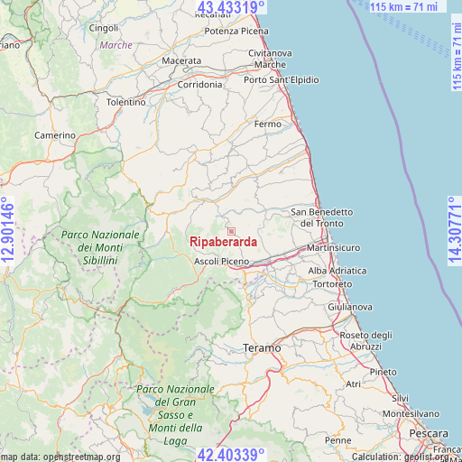
Ripaberarda GPS coordinates[2]
42° 55' 13.584" North, 13° 36' 16.488" East
| Map corner | latitude | longitude |
|---|---|---|
| Upper-left | 43.43319°, | 12.90146° |
| Center: | 42.92044°, | 13.60458° |
| Lower-right: | 42.40339°, | 14.30771° |
| Map W x H: | 114.5×114.5 km | = 71.1×71.1mi |
| max Lat: | 47.04031° ⇑63.8% North |
| Ripaberarda: | 42.92044° |
| min Lat: | ⇓36.2% South 35.50142° |
| min Long | Ripaberarda | max Long |
| 6.69888° | 13.60458° | 18.48682° |
| W 74.7%⇐ | ⇒25.3% E |
Elevation
Elevation of Ripaberarda is 402 m = 1319 ft, and this is 95.3 m = 313 ft above average elevation for this country.
| Max E: |
2085 m = 6841 ft | 29.2% |
| Ripaberarda | 402 m 1319 ft | |
| Avg. | 306.7 m = 1006 ft | |
Min E: |
-4 m = -13 ft | 70.8% |
See also: Italy elevation on elevation.city.
Geographical zone
Ripaberarda is located in North temperate zone (between Tropic of Cancer and the Arctic Circle). Distance of this Northern Tropic circle is 2166.4 km =1346.1 mi to South.| Distance of | km | miles | from Ripaberarda |
|---|---|---|---|
| North Pole | 5234.8 | 3252.8 | to North |
| Arctic Circle | 2628.9 | 1633.5 | to North |
| Tropic Cancer | 2166.4 | 1346.1 | to South |
| Equator | 4772.3 | 2965.4 | to South |


Nearby cities:
15 places around Ripaberarda: (largest is in red/bold)
• Appignano del Tronto
5.3 km =3.3 mi,  117°
117°
• Ascoli Piceno
7.8 km =4.8 mi,  198°
198°
• Campolungo-Villa Sant'Antonio
10.1 km =6.3 mi,  140°
140°
• Caselle
10.3 km =6.4 mi,  148°
148°
• Castignano
2.7 km =1.7 mi,  38°
38°
• Castorano
10.5 km =6.5 mi,  103°
103°
• Cossignano
9.9 km =6.2 mi, 44°
• Montalto delle Marche
7.7 km =4.8 mi,  2°
2°
• Montedinove
5.9 km =3.7 mi,  348°
348°
• Offida
7.8 km =4.8 mi,  77°
77°
• Piagge
9.5 km =5.9 mi,  194°
194°
• Rotella
5.3 km =3.3 mi,  315°
315°
• Venagrande
6 km =3.7 mi,  236°
236°
• Venarotta
10.1 km =6.3 mi,  245°
245°
• Villa Pigna
10 km =6.2 mi,  165°
165°
Sources, notices
• [Note1] Compared only with cities in Italy existing in our database
• [Src1] Map data: © OpenStreetMap contributors (CC-BY-SA)
• [Src2] Other city data from geonames.org with taken over terms of usage.
• [Src3] Geographical zone / Annual Mean Temperature by Robert A. Rohde @ Wikipedia
