Piagge geodata
Piagge (The Marches) is a populated place; located in Italy in Europe/Rome (GMT+2) time zone. With population of 566 people, there are 9291 cities with bigger population in this country. Compared to other cities in Italy, 64.4% of cities are located further ↑North; 74.4% of cities are located further ←West and 76.7% of cities have lower elevation than Piagge. Note1
Administrative division(s):
- Level 1: The Marches
- Level 2: Provincia di Ascoli Piceno
- Level 3: Ascoli Piceno


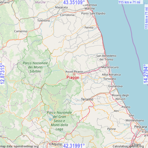
Piagge GPS coordinates[2]
42° 50' 15.54" North, 13° 34' 34.572" East
| Map corner | latitude | longitude |
|---|---|---|
| Upper-left | 43.35109°, | 12.87315° |
| Center: | 42.83765°, | 13.57627° |
| Lower-right: | 42.31991°, | 14.2794° |
| Map W x H: | 114.7×114.7 km | = 71.3×71.3mi |
| max Lat: | 47.04031° ⇑64.4% North |
| Piagge: | 42.83765° |
| min Lat: | ⇓35.6% South 35.50142° |
| min Long | Piagge | max Long |
| 6.69888° | 13.57627° | 18.48682° |
| W 74.4%⇐ | ⇒25.6% E |
Elevation
Elevation of Piagge is 476 m = 1562 ft, and this is 169.3 m = 555 ft above average elevation for this country.
| Max E: |
2085 m = 6841 ft | 23.3% |
| Piagge | 476 m 1562 ft | |
| Avg. | 306.7 m = 1006 ft | |
Min E: |
-4 m = -13 ft | 76.7% |
See also: Italy elevation on elevation.city.
Geographical zone
Piagge is located in North temperate zone (between Tropic of Cancer and the Arctic Circle). Distance of this Northern Tropic circle is 2157.2 km =1340.4 mi to South.| Distance of | km | miles | from Piagge |
|---|---|---|---|
| North Pole | 5244 | 3258.5 | to North |
| Arctic Circle | 2638.1 | 1639.2 | to North |
| Tropic Cancer | 2157.2 | 1340.4 | to South |
| Equator | 4763.1 | 2959.7 | to South |


Nearby cities:
15 places around Piagge: (largest is in red/bold)
• Appignano del Tronto
9.7 km =6 mi,  46°
46°
• Ascoli Piceno
1.8 km =1.1 mi,  353°
353°
• Campolungo-Villa Sant'Antonio
8.8 km =5.5 mi,  81°
81°
• Caselle
7.8 km =4.8 mi,  86°
86°
• Civitella del Tronto
10.9 km =6.8 mi,  131°
131°
• Folignano
5 km =3.1 mi,  112°
112°
• Maltignano
9.1 km =5.7 mi, 93°
• Marsia
8.5 km =5.3 mi,  287°
287°
• Mozzano
5.3 km =3.3 mi,  260°
260°
• Piane di Morro
6.5 km =4 mi,  104°
104°
• Ripaberarda
9.5 km =5.9 mi,  14°
14°
• Venagrande
6.5 km =4 mi,  335°
335°
• Venarotta
8.5 km =5.3 mi,  305°
305°
• Villa Lempa
7.4 km =4.6 mi, 131°
• Villa Pigna
4.8 km =3 mi, 95°
Sources, notices
• [Note1] Compared only with cities in Italy existing in our database
• [Src1] Map data: © OpenStreetMap contributors (CC-BY-SA)
• [Src2] Other city data from geonames.org with taken over terms of usage.
• [Src3] Geographical zone / Annual Mean Temperature by Robert A. Rohde @ Wikipedia
