Resiutta geodata
Resiutta (Friuli Venezia Giulia) is a seat of a third-order administrative division; located in Italy in Europe/Rome (GMT+2) time zone. With population of 233 people, there are 10964 cities with bigger population in this country. Compared to other cities in Italy, 97.5% of cities are located further ↓South; 70.5% of cities are located further ←West and 62.1% of cities have lower elevation than Resiutta. Note1
Administrative division(s):
- Level 1: Friuli Venezia Giulia
- Level 2: Provincia di Udine
- Level 3: Resiutta


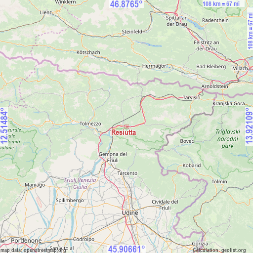
Resiutta GPS coordinates[2]
46° 23' 37.356" North, 13° 13' 4.656" East
| Map corner | latitude | longitude |
|---|---|---|
| Upper-left | 46.8765°, | 12.51484° |
| Center: | 46.39371°, | 13.21796° |
| Lower-right: | 45.90661°, | 13.92109° |
| Map W x H: | 107.8×107.8 km | = 67×67mi |
| max Lat: | 47.04031° ⇑2.5% North |
| Resiutta: | 46.39371° |
| min Lat: | ⇓97.5% South 35.50142° |
| min Long | Resiutta | max Long |
| 6.69888° | 13.21796° | 18.48682° |
| W 70.5%⇐ | ⇒29.5% E |
Elevation
Elevation of Resiutta is 316 m = 1037 ft, and this is 9.3 m = 31 ft above average elevation for this country.
| Max E: |
2085 m = 6841 ft | 37.9% |
| Resiutta | 316 m 1037 ft | |
| Avg. | 306.7 m = 1006 ft | |
Min E: |
-4 m = -13 ft | 62.1% |
See also: Italy elevation on elevation.city.
Geographical zone
Resiutta is located in North temperate zone (between Tropic of Cancer and the Arctic Circle). Distance of this North polar circle is 2242.7 km =1393.5 mi to North.| Distance of | km | miles | from Resiutta |
|---|---|---|---|
| North Pole | 4848.6 | 3012.8 | to North |
| Arctic Circle | 2242.7 | 1393.5 | to North |
| Tropic Cancer | 2552.6 | 1586.1 | to South |
| Equator | 5158.5 | 3205.3 | to South |


Nearby cities:
15 places around Resiutta: (largest is in red/bold)
• Alesso
15.3 km =9.5 mi,  235°
235°
• Amaro
9.8 km =6.1 mi,  256°
256°
• Bordano
12.3 km =7.6 mi,  224°
224°
• Cavazzo Carnico
13.9 km =8.6 mi, 258°
• Chiusaforte
6.9 km =4.3 mi,  77°
77°
• Dogna
9.6 km =6 mi,  50°
50°
• Gemona
15.2 km =9.4 mi,  208°
208°
• Isola
15.6 km =9.7 mi,  191°
191°
• Lusevera
13.7 km =8.5 mi,  163°
163°
• Moggio Udinese
2.3 km =1.4 mi,  326°
326°
• Moggio di Sotto
2.3 km =1.4 mi,  309°
309°
• Pontebba
14.1 km =8.8 mi,  28°
28°
• Prato
7.2 km =4.5 mi,  108°
108°
• Tolmezzo
15.2 km =9.4 mi,  272°
272°
• Venzone
9.3 km =5.8 mi, 220°
Sources, notices
• [Note1] Compared only with cities in Italy existing in our database
• [Src1] Map data: © OpenStreetMap contributors (CC-BY-SA)
• [Src2] Other city data from geonames.org with taken over terms of usage.
• [Src3] Geographical zone / Annual Mean Temperature by Robert A. Rohde @ Wikipedia
