Prato geodata
Prato (Friuli Venezia Giulia) is a seat of a third-order administrative division; located in Italy in Europe/Rome (GMT+2) time zone. With population of 423 people, there are 10189 cities with bigger population in this country. Compared to other cities in Italy, 97.4% of cities are located further ↓South; 71.5% of cities are located further ←West and 78% of cities have lower elevation than Prato. Note1
Administrative division(s):
- Level 1: Friuli Venezia Giulia
- Level 2: Provincia di Udine
- Level 3: Resia


Prato GPS coordinates[2]
46° 22' 25.104" North, 13° 18' 23.724" East
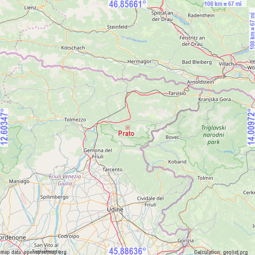
| Map corner | latitude | longitude |
|---|---|---|
| Upper-left | 46.85661°, | 12.60347° |
| Center: | 46.37364°, | 13.30659° |
| Lower-right: | 45.88636°, | 14.00972° |
| Map W x H: | 107.9×107.9 km | = 67×67mi |
| max Lat: | 47.04031° ⇑2.6% North |
| Prato: | 46.37364° |
| min Lat: | ⇓97.4% South 35.50142° |
| min Long | Prato | max Long |
| 6.69888° | 13.30659° | 18.48682° |
| W 71.5%⇐ | ⇒28.5% E |
Elevation
Elevation of Prato is 492 m = 1614 ft, and this is 185.3 m = 608 ft above average elevation for this country.
| Max E: |
2085 m = 6841 ft | 22% |
| Prato | 492 m 1614 ft | |
| Avg. | 306.7 m = 1006 ft | |
Min E: |
-4 m = -13 ft | 78% |
See also: Italy elevation on elevation.city.
Geographical zone
Prato is located in North temperate zone (between Tropic of Cancer and the Arctic Circle). Distance of this North polar circle is 2244.9 km =1394.9 mi to North.| Distance of | km | miles | from Prato |
|---|---|---|---|
| North Pole | 4850.8 | 3014.1 | to North |
| Arctic Circle | 2244.9 | 1394.9 | to North |
| Tropic Cancer | 2550.3 | 1584.7 | to South |
| Equator | 5156.3 | 3204 | to South |


Nearby cities:
15 places around Prato: (largest is in red/bold)
• Amaro
16.3 km =10.1 mi,  270°
270°
• Bordano
16.8 km =10.4 mi,  247°
247°
• Chiusaforte
3.7 km =2.3 mi,  358°
358°
• Dogna
8.3 km =5.2 mi,  4°
4°
• Gemona
18 km =11.2 mi,  231°
231°
• Isola
16.4 km =10.2 mi,  216°
216°
• Lusevera
11.3 km =7 mi,  194°
194°
• Malborghetto
18 km =11.2 mi,  34°
34°
• Moggio Udinese
9.1 km =5.7 mi,  297°
297°
• Moggio di Sotto
9.3 km =5.8 mi,  293°
293°
• Montenars
17.2 km =10.7 mi, 217°
• Pontebba
14.7 km =9.1 mi, 359°
• Resiutta
7.2 km =4.5 mi, 288°
• Taipana
14.1 km =8.8 mi,  169°
169°
• Venzone
13.8 km =8.6 mi, 249°
Sources, notices
• [Note1] Compared only with cities in Italy existing in our database
• [Src1] Map data: © OpenStreetMap contributors (CC-BY-SA)
• [Src2] Other city data from geonames.org with taken over terms of usage.
• [Src3] Geographical zone / Annual Mean Temperature by Robert A. Rohde @ Wikipedia
