Chiusaforte geodata
Chiusaforte (Friuli Venezia Giulia) is a seat of a third-order administrative division; located in Italy in Europe/Rome (GMT+2) time zone. With population of 246 people, there are 10911 cities with bigger population in this country. Compared to other cities in Italy, 97.7% of cities are located further ↓South; 71.4% of cities are located further ←West and 68.7% of cities have lower elevation than Chiusaforte. Note1
Administrative division(s):
- Level 1: Friuli Venezia Giulia
- Level 2: Provincia di Udine
- Level 3: Chiusaforte


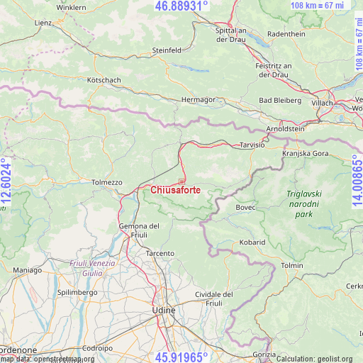
Chiusaforte GPS coordinates[2]
46° 24' 23.868" North, 13° 18' 19.872" East
| Map corner | latitude | longitude |
|---|---|---|
| Upper-left | 46.88931°, | 12.6024° |
| Center: | 46.40663°, | 13.30552° |
| Lower-right: | 45.91965°, | 14.00865° |
| Map W x H: | 107.8×107.8 km | = 67×67mi |
| max Lat: | 47.04031° ⇑2.3% North |
| Chiusaforte: | 46.40663° |
| min Lat: | ⇓97.7% South 35.50142° |
| min Long | Chiusaforte | max Long |
| 6.69888° | 13.30552° | 18.48682° |
| W 71.4%⇐ | ⇒28.6% E |
Elevation
Elevation of Chiusaforte is 381 m = 1250 ft, and this is 74.3 m = 244 ft above average elevation for this country.
| Max E: |
2085 m = 6841 ft | 31.3% |
| Chiusaforte | 381 m 1250 ft | |
| Avg. | 306.7 m = 1006 ft | |
Min E: |
-4 m = -13 ft | 68.7% |
See also: Italy elevation on elevation.city.
Geographical zone
Chiusaforte is located in North temperate zone (between Tropic of Cancer and the Arctic Circle). Distance of this North polar circle is 2241.2 km =1392.6 mi to North.| Distance of | km | miles | from Chiusaforte |
|---|---|---|---|
| North Pole | 4847.1 | 3011.8 | to North |
| Arctic Circle | 2241.2 | 1392.6 | to North |
| Tropic Cancer | 2554 | 1587 | to South |
| Equator | 5159.9 | 3206.2 | to South |


Nearby cities:
15 places around Chiusaforte: (largest is in red/bold)
• Amaro
16.7 km =10.4 mi,  257°
257°
• Bordano
18.4 km =11.4 mi,  236°
236°
• Dogna
4.6 km =2.9 mi,  9°
9°
• Isola
19.4 km =12.1 mi,  210°
210°
• Lusevera
14.9 km =9.3 mi,  190°
190°
• Malborghetto
15.1 km =9.4 mi,  42°
42°
• Moggio Udinese
8 km =5 mi,  273°
273°
• Moggio di Sotto
8.5 km =5.3 mi, 269°
• Montenars
20.2 km =12.6 mi, 211°
• Paularo
19.9 km =12.4 mi,  314°
314°
• Pontebba
11 km =6.8 mi,  0°
0°
• Prato
3.7 km =2.3 mi,  178°
178°
• Resiutta
6.9 km =4.3 mi, 257°
• Taipana
17.7 km =11 mi,  171°
171°
• Venzone
15.4 km =9.6 mi, 236°
Sources, notices
• [Note1] Compared only with cities in Italy existing in our database
• [Src1] Map data: © OpenStreetMap contributors (CC-BY-SA)
• [Src2] Other city data from geonames.org with taken over terms of usage.
• [Src3] Geographical zone / Annual Mean Temperature by Robert A. Rohde @ Wikipedia
