Fontegreca geodata
Fontegreca (Campania) is a seat of a third-order administrative division; located in Italy in Europe/Rome (GMT+2) time zone. With population of 707 people, there are 8250 cities with bigger population in this country. Compared to other cities in Italy, 75.2% of cities are located further ↑North; 79.6% of cities are located further ←West and 62.8% of cities have lower elevation than Fontegreca. Note1


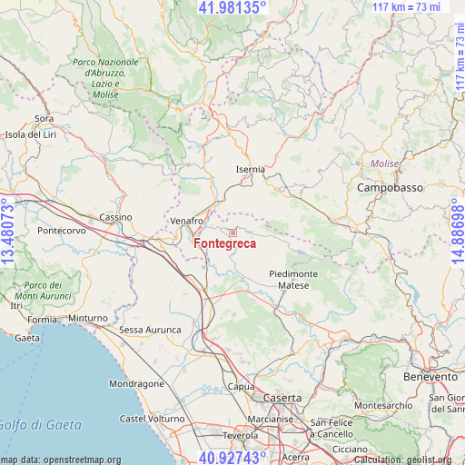
Fontegreca GPS coordinates[2]
41° 27' 23.508" North, 14° 11' 1.86" East
| Map corner | latitude | longitude |
|---|---|---|
| Upper-left | 41.98135°, | 13.48073° |
| Center: | 41.45653°, | 14.18385° |
| Lower-right: | 40.92743°, | 14.88698° |
| Map W x H: | 117.2×117.2 km | = 72.8×72.8mi |
| max Lat: | 47.04031° ⇑75.2% North |
| Fontegreca: | 41.45653° |
| min Lat: | ⇓24.8% South 35.50142° |
| min Long | Fontegreca | max Long |
| 6.69888° | 14.18385° | 18.48682° |
| W 79.6%⇐ | ⇒20.4% E |
Elevation
Elevation of Fontegreca is 321 m = 1053 ft, and this is 14.3 m = 47 ft above average elevation for this country.
| Max E: |
2085 m = 6841 ft | 37.2% |
| Fontegreca | 321 m 1053 ft | |
| Avg. | 306.7 m = 1006 ft | |
Min E: |
-4 m = -13 ft | 62.8% |
See also: Italy elevation on elevation.city.
Geographical zone
Fontegreca is located in North temperate zone (between Tropic of Cancer and the Arctic Circle). Distance of this Northern Tropic circle is 2003.6 km =1245 mi to South.| Distance of | km | miles | from Fontegreca |
|---|---|---|---|
| North Pole | 5397.5 | 3353.8 | to North |
| Arctic Circle | 2791.6 | 1734.6 | to North |
| Tropic Cancer | 2003.6 | 1245 | to South |
| Equator | 4609.5 | 2864.2 | to South |


Nearby cities:
15 places around Fontegreca: (largest is in red/bold)
• Ailano
7.6 km =4.7 mi,  166°
166°
• Capriati A Volturno
3.4 km =2.1 mi,  292°
292°
• Ciorlano
2.2 km =1.4 mi,  251°
251°
• Gallo
3.6 km =2.2 mi,  74°
74°
• Gallo Matese
3.5 km =2.2 mi,  75°
75°
• Letino
6 km =3.7 mi,  93°
93°
• Longano
9 km =5.6 mi,  35°
35°
• Monteroduni
7.4 km =4.6 mi,  355°
355°
• Prata Sannita Centro
3.1 km =1.9 mi,  149°
149°
• Pratella
5.7 km =3.5 mi,  183°
183°
• Sant'Eusanio
8.6 km =5.3 mi,  341°
341°
• Selvotta
9 km =5.6 mi,  242°
242°
• Sesto Campano
9.7 km =6 mi, 245°
• Taverna Ravindola
8.8 km =5.5 mi,  326°
326°
• Valle Agricola
7 km =4.3 mi,  120°
120°
Sources, notices
• [Note1] Compared only with cities in Italy existing in our database
• [Src1] Map data: © OpenStreetMap contributors (CC-BY-SA)
• [Src2] Other city data from geonames.org with taken over terms of usage.
• [Src3] Geographical zone / Annual Mean Temperature by Robert A. Rohde @ Wikipedia
