Parlasco geodata
Parlasco (Lombardy) is a seat of a third-order administrative division; located in Italy in Europe/Rome (GMT+2) time zone. With population of 131 people, there are 11347 cities with bigger population in this country. Compared to other cities in Italy, 92.4% of cities are located further ↓South; 75.6% of cities are located further →East and 88.9% of cities have lower elevation than Parlasco. Note1


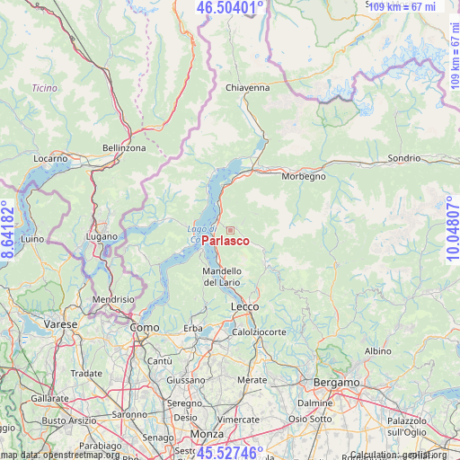
Parlasco GPS coordinates[2]
46° 1' 4.404" North, 9° 20' 41.784" East
| Map corner | latitude | longitude |
|---|---|---|
| Upper-left | 46.50401°, | 8.64182° |
| Center: | 46.01789°, | 9.34494° |
| Lower-right: | 45.52746°, | 10.04807° |
| Map W x H: | 108.6×108.6 km | = 67.5×67.5mi |
| max Lat: | 47.04031° ⇑7.6% North |
| Parlasco: | 46.01789° |
| min Lat: | ⇓92.4% South 35.50142° |
| min Long | Parlasco | max Long |
| 6.69888° | 9.34494° | 18.48682° |
| W 24.4%⇐ | ⇒75.6% E |
Elevation
Elevation of Parlasco is 692 m = 2270 ft, and this is 385.3 m = 1264 ft above average elevation for this country.
| Max E: |
2085 m = 6841 ft | 11.1% |
| Parlasco | 692 m 2270 ft | |
| Avg. | 306.7 m = 1006 ft | |
Min E: |
-4 m = -13 ft | 88.9% |
See also: Italy elevation on elevation.city.
Geographical zone
Parlasco is located in North temperate zone (between Tropic of Cancer and the Arctic Circle). Distance of this North polar circle is 2284.5 km =1419.5 mi to North.| Distance of | km | miles | from Parlasco |
|---|---|---|---|
| North Pole | 4890.4 | 3038.8 | to North |
| Arctic Circle | 2284.5 | 1419.5 | to North |
| Tropic Cancer | 2510.8 | 1560.1 | to South |
| Equator | 5116.7 | 3179.4 | to South |


Nearby cities:
15 places around Parlasco: (largest is in red/bold)
• Bellagio
7.2 km =4.5 mi,  242°
242°
• Bellano
4.1 km =2.5 mi,  315°
315°
• Casargo
4 km =2.5 mi,  53°
53°
• Cortenova
3.6 km =2.2 mi,  122°
122°
• Crandola Valsassina
2.7 km =1.7 mi,  77°
77°
• Esino Lario
2.7 km =1.7 mi,  197°
197°
• Introzzo
7 km =4.3 mi,  357°
357°
• Margno
3.2 km =2 mi,  62°
62°
• Pagnona
6.4 km =4 mi,  43°
43°
• Perledo
3.8 km =2.4 mi,  265°
265°
• Premana
7 km =4.3 mi, 56°
• Taceno
1.6 km =1 mi,  70°
70°
• Tremenico
6.7 km =4.2 mi,  14°
14°
• Varenna
4.7 km =2.9 mi,  260°
260°
• Vendrogno
2.2 km =1.4 mi,  326°
326°
Sources, notices
• [Note1] Compared only with cities in Italy existing in our database
• [Src1] Map data: © OpenStreetMap contributors (CC-BY-SA)
• [Src2] Other city data from geonames.org with taken over terms of usage.
• [Src3] Geographical zone / Annual Mean Temperature by Robert A. Rohde @ Wikipedia
