Pozza geodata
Pozza (Emilia-Romagna) is a populated place; located in Italy in Europe/Rome (GMT+2) time zone. With population of 2,882 people, there are 3133 cities with bigger population in this country. Compared to other cities in Italy, 51.4% of cities are located further ↓South; 58.6% of cities are located further →East and 65.3% of cities have higher elevation than Pozza. Note1


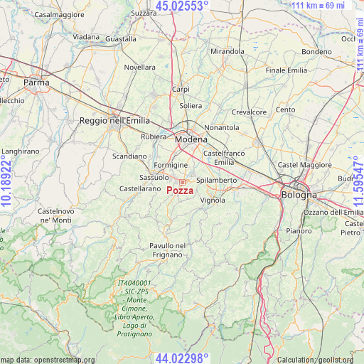
Pozza GPS coordinates[2]
44° 31' 35.076" North, 10° 53' 32.424" East
| Map corner | latitude | longitude |
|---|---|---|
| Upper-left | 45.02553°, | 10.18922° |
| Center: | 44.52641°, | 10.89234° |
| Lower-right: | 44.02298°, | 11.59547° |
| Map W x H: | 111.5×111.5 km | = 69.3×69.3mi |
| max Lat: | 47.04031° ⇑48.6% North |
| Pozza: | 44.52641° |
| min Lat: | ⇓51.4% South 35.50142° |
| min Long | Pozza | max Long |
| 6.69888° | 10.89234° | 18.48682° |
| W 41.4%⇐ | ⇒58.6% E |
Elevation
Elevation of Pozza is 126 m = 413 ft, and this is 180.7 m = 593 ft below average elevation for this country.
| Max E: |
2085 m = 6841 ft | 65.3% |
| Avg. | 306.7 m = 1006 ft | |
| Pozza | 126 m = 413 ft | |
Min E: |
-4 m = -13 ft | 34.7% |
See also: Italy elevation on elevation.city.
Geographical zone
Pozza is located in North temperate zone (between Tropic of Cancer and the Arctic Circle). Distance of this Northern Tropic circle is 2345 km =1457.1 mi to South.| Distance of | km | miles | from Pozza |
|---|---|---|---|
| North Pole | 5056.2 | 3141.8 | to North |
| Arctic Circle | 2450.3 | 1522.5 | to North |
| Tropic Cancer | 2345 | 1457.1 | to South |
| Equator | 4950.9 | 3076.3 | to South |


Nearby cities:
15 places around Pozza: (largest is in red/bold)
• Ca' di Sola
4.9 km =3 mi,  85°
85°
• Castelnuovo Rangone
4.1 km =2.5 mi,  51°
51°
• Castelvetro di Modena
5 km =3.1 mi,  119°
119°
• Colombaro
2.8 km =1.7 mi,  6°
6°
• Fiorano
6.5 km =4 mi,  282°
282°
• Formigine
6.3 km =3.9 mi,  325°
325°
• Gorzano
1.5 km =0.9 mi,  221°
221°
• Levizzano Rangone
4.8 km =3 mi,  163°
163°
• Maranello
1.9 km =1.2 mi,  285°
285°
• Montale
4.9 km =3 mi, 14°
• Portile
7.1 km =4.4 mi,  30°
30°
• San Venanzio
4.1 km =2.5 mi, 222°
• San Vito
7.4 km =4.6 mi,  61°
61°
• Solignano Nuovo
2.7 km =1.7 mi, 87°
• Torre Maina
3.4 km =2.1 mi,  206°
206°
Sources, notices
• [Note1] Compared only with cities in Italy existing in our database
• [Src1] Map data: © OpenStreetMap contributors (CC-BY-SA)
• [Src2] Other city data from geonames.org with taken over terms of usage.
• [Src3] Geographical zone / Annual Mean Temperature by Robert A. Rohde @ Wikipedia
