Maranello geodata
Maranello (Emilia-Romagna) is a seat of a third-order administrative division; located in Italy in Europe/Rome (GMT+2) time zone. With population of 9,228 people, there are 1027 cities with bigger population in this country. Compared to other cities in Italy, 51.5% of cities are located further ↓South; 58.9% of cities are located further →East and 64.7% of cities have higher elevation than Maranello. Note1


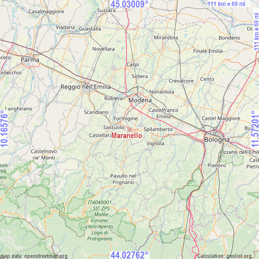
Maranello GPS coordinates[2]
44° 31' 51.636" North, 10° 52' 7.968" East
| Map corner | latitude | longitude |
|---|---|---|
| Upper-left | 45.03009°, | 10.16576° |
| Center: | 44.53101°, | 10.86888° |
| Lower-right: | 44.02762°, | 11.57201° |
| Map W x H: | 111.5×111.5 km | = 69.3×69.3mi |
| max Lat: | 47.04031° ⇑48.5% North |
| Maranello: | 44.53101° |
| min Lat: | ⇓51.5% South 35.50142° |
| min Long | Maranello | max Long |
| 6.69888° | 10.86888° | 18.48682° |
| W 41.1%⇐ | ⇒58.9% E |
Elevation
Elevation of Maranello is 129 m = 423 ft, and this is 177.7 m = 583 ft below average elevation for this country.
| Max E: |
2085 m = 6841 ft | 64.7% |
| Avg. | 306.7 m = 1006 ft | |
| Maranello | 129 m = 423 ft | |
Min E: |
-4 m = -13 ft | 35.3% |
See also: Italy elevation on elevation.city.
Geographical zone
Maranello is located in North temperate zone (between Tropic of Cancer and the Arctic Circle). Distance of this Northern Tropic circle is 2345.5 km =1457.4 mi to South.| Distance of | km | miles | from Maranello |
|---|---|---|---|
| North Pole | 5055.7 | 3141.5 | to North |
| Arctic Circle | 2449.8 | 1522.2 | to North |
| Tropic Cancer | 2345.5 | 1457.4 | to South |
| Equator | 4951.4 | 3076.7 | to South |


Nearby cities:
15 places around Maranello: (largest is in red/bold)
• Ca' di Sola
6.8 km =4.2 mi,  91°
91°
• Castelnuovo Rangone
5.5 km =3.4 mi,  68°
68°
• Castelvetro di Modena
6.8 km =4.2 mi,  115°
115°
• Colombaro
3.1 km =1.9 mi,  43°
43°
• Fiorano
4.6 km =2.9 mi,  280°
280°
• Formigine
4.9 km =3 mi,  339°
339°
• Gorzano
1.9 km =1.2 mi,  152°
152°
• Levizzano Rangone
6 km =3.7 mi, 147°
• Montale
5.2 km =3.2 mi, 35°
• Portile
7.8 km =4.8 mi, 44°
• Pozza
1.9 km =1.2 mi,  105°
105°
• San Venanzio
3.6 km =2.2 mi,  194°
194°
• Sassuolo
6.8 km =4.2 mi, 281°
• Solignano Nuovo
4.6 km =2.9 mi, 94°
• Torre Maina
3.6 km =2.2 mi,  174°
174°
Sources, notices
• [Note1] Compared only with cities in Italy existing in our database
• [Src1] Map data: © OpenStreetMap contributors (CC-BY-SA)
• [Src2] Other city data from geonames.org with taken over terms of usage.
• [Src3] Geographical zone / Annual Mean Temperature by Robert A. Rohde @ Wikipedia
