Mombelli geodata
Mombelli (Lombardy) is a seat of a third-order administrative division; located in Italy in Europe/Rome (GMT+2) time zone. With population of 154 people, there are 11267 cities with bigger population in this country. Compared to other cities in Italy, 57.4% of cities are located further ↓South; 77.5% of cities are located further →East and 82.4% of cities have lower elevation than Mombelli. Note1


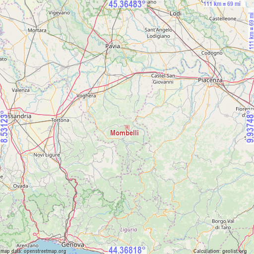
Mombelli GPS coordinates[2]
44° 52' 7.176" North, 9° 14' 3.696" East
| Map corner | latitude | longitude |
|---|---|---|
| Upper-left | 45.36483°, | 8.53123° |
| Center: | 44.86866°, | 9.23436° |
| Lower-right: | 44.36818°, | 9.93748° |
| Map W x H: | 110.8×110.8 km | = 68.8×68.8mi |
| max Lat: | 47.04031° ⇑42.6% North |
| Mombelli: | 44.86866° |
| min Lat: | ⇓57.4% South 35.50142° |
| min Long | Mombelli | max Long |
| 6.69888° | 9.23436° | 18.48682° |
| W 22.5%⇐ | ⇒77.5% E |
Elevation
Elevation of Mombelli is 562 m = 1844 ft, and this is 255.3 m = 838 ft above average elevation for this country.
| Max E: |
2085 m = 6841 ft | 17.6% |
| Mombelli | 562 m 1844 ft | |
| Avg. | 306.7 m = 1006 ft | |
Min E: |
-4 m = -13 ft | 82.4% |
See also: Italy elevation on elevation.city.
Geographical zone
Mombelli is located in North temperate zone (between Tropic of Cancer and the Arctic Circle). Distance of this Northern Tropic circle is 2383 km =1480.7 mi to South.| Distance of | km | miles | from Mombelli |
|---|---|---|---|
| North Pole | 5018.1 | 3118.1 | to North |
| Arctic Circle | 2412.2 | 1498.9 | to North |
| Tropic Cancer | 2383 | 1480.7 | to South |
| Equator | 4988.9 | 3100 | to South |


Nearby cities:
15 places around Mombelli: (largest is in red/bold)
• Bagnaria
9.9 km =6.2 mi,  242°
242°
• Borgoratto Mormorolo
7.4 km =4.6 mi,  334°
334°
• Caminata
7.4 km =4.6 mi,  51°
51°
• Casa Ponte
5.6 km =3.5 mi,  280°
280°
• Caseo
8.9 km =5.5 mi,  21°
21°
• Fortunago
7.1 km =4.4 mi, 326°
• Menconico
8.8 km =5.5 mi,  156°
156°
• Montesegale
9.5 km =5.9 mi,  296°
296°
• Nibbiano
8.4 km =5.2 mi,  61°
61°
• Pometo
7.3 km =4.5 mi,  25°
25°
• Romagnese
8 km =5 mi,  112°
112°
• Ruino
5.8 km =3.6 mi, 34°
• Solaro
5 km =3.1 mi, 284°
• Varzi
5.8 km =3.6 mi,  209°
209°
• Zavattarello
2.5 km =1.6 mi,  92°
92°
Sources, notices
• [Note1] Compared only with cities in Italy existing in our database
• [Src1] Map data: © OpenStreetMap contributors (CC-BY-SA)
• [Src2] Other city data from geonames.org with taken over terms of usage.
• [Src3] Geographical zone / Annual Mean Temperature by Robert A. Rohde @ Wikipedia
