Ploaghe geodata
Ploaghe (Sardinia) is a seat of a third-order administrative division; located in Italy in Europe/Rome (GMT+2) time zone. With population of 4,516 people, there are 2139 cities with bigger population in this country. Compared to other cities in Italy, 82.7% of cities are located further ↑North; 84.8% of cities are located further →East and 73.9% of cities have lower elevation than Ploaghe. Note1


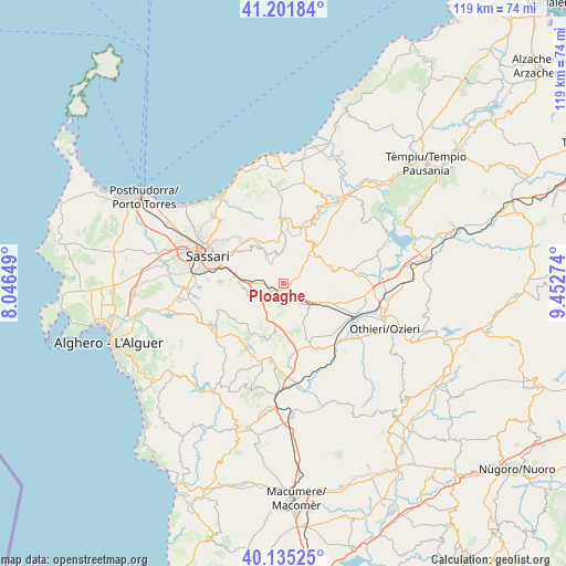
Ploaghe GPS coordinates[2]
40° 40' 14.448" North, 8° 44' 58.632" East
| Map corner | latitude | longitude |
|---|---|---|
| Upper-left | 41.20184°, | 8.04649° |
| Center: | 40.67068°, | 8.74962° |
| Lower-right: | 40.13525°, | 9.45274° |
| Map W x H: | 118.6×118.6 km | = 73.7×73.7mi |
| max Lat: | 47.04031° ⇑82.7% North |
| Ploaghe: | 40.67068° |
| min Lat: | ⇓17.3% South 35.50142° |
| min Long | Ploaghe | max Long |
| 6.69888° | 8.74962° | 18.48682° |
| W 15.2%⇐ | ⇒84.8% E |
Elevation
Elevation of Ploaghe is 438 m = 1437 ft, and this is 131.3 m = 431 ft above average elevation for this country.
| Max E: |
2085 m = 6841 ft | 26.1% |
| Ploaghe | 438 m 1437 ft | |
| Avg. | 306.7 m = 1006 ft | |
Min E: |
-4 m = -13 ft | 73.9% |
See also: Italy elevation on elevation.city.
Geographical zone
Ploaghe is located in North temperate zone (between Tropic of Cancer and the Arctic Circle). Distance of this Northern Tropic circle is 1916.2 km =1190.7 mi to South.| Distance of | km | miles | from Ploaghe |
|---|---|---|---|
| North Pole | 5484.9 | 3408.2 | to North |
| Arctic Circle | 2879 | 1788.9 | to North |
| Tropic Cancer | 1916.2 | 1190.7 | to South |
| Equator | 4522.2 | 2810 | to South |


Nearby cities:
15 places around Ploaghe: (largest is in red/bold)
• Ardara
7.5 km =4.7 mi,  137°
137°
• Banari
11.9 km =7.4 mi,  200°
200°
• Bessude
13.1 km =8.1 mi,  188°
188°
• Bonnanaro
15.4 km =9.6 mi,  175°
175°
• Cargeghe
11.3 km =7 mi,  269°
269°
• Chiaramonti
10.5 km =6.5 mi,  34°
34°
• Codrongianos
6 km =3.7 mi,  254°
254°
• Florinas
7.5 km =4.7 mi, 251°
• Martis
12.9 km =8 mi,  22°
22°
• Mores
15.4 km =9.6 mi,  152°
152°
• Muros
11.2 km =7 mi, 274°
• Nulvi
12.7 km =7.9 mi,  357°
357°
• Osilo
10.5 km =6.5 mi,  320°
320°
• Ossi
13.3 km =8.3 mi, 271°
• Siligo
10.8 km =6.7 mi, 189°
Sources, notices
• [Note1] Compared only with cities in Italy existing in our database
• [Src1] Map data: © OpenStreetMap contributors (CC-BY-SA)
• [Src2] Other city data from geonames.org with taken over terms of usage.
• [Src3] Geographical zone / Annual Mean Temperature by Robert A. Rohde @ Wikipedia
