Pianacce geodata
Pianacce (Abruzzo) is a populated place; located in Italy in Europe/Rome (GMT+2) time zone. With population of 799 people, there are 7649 cities with bigger population in this country. Compared to other cities in Italy, 65.9% of cities are located further ↑North; 78.9% of cities are located further ←West and 50.8% of cities have higher elevation than Pianacce. Note1


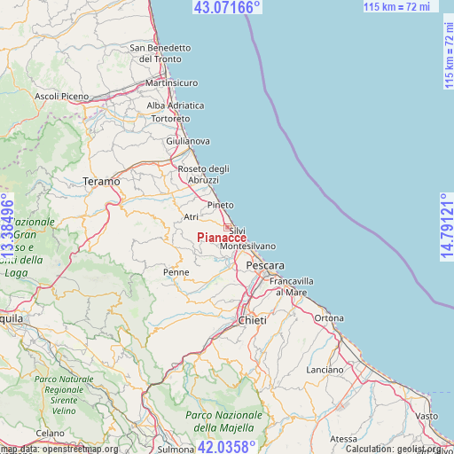
Pianacce GPS coordinates[2]
42° 33' 21.168" North, 14° 5' 17.088" East
| Map corner | latitude | longitude |
|---|---|---|
| Upper-left | 43.07166°, | 13.38496° |
| Center: | 42.55588°, | 14.08808° |
| Lower-right: | 42.0358°, | 14.79121° |
| Map W x H: | 115.2×115.2 km | = 71.6×71.6mi |
| max Lat: | 47.04031° ⇑65.9% North |
| Pianacce: | 42.55588° |
| min Lat: | ⇓34.1% South 35.50142° |
| min Long | Pianacce | max Long |
| 6.69888° | 14.08808° | 18.48682° |
| W 78.9%⇐ | ⇒21.1% E |
Elevation
Elevation of Pianacce is 230 m = 755 ft, and this is 76.7 m = 252 ft below average elevation for this country.
| Max E: |
2085 m = 6841 ft | 50.8% |
| Avg. | 306.7 m = 1006 ft | |
| Pianacce | 230 m = 755 ft | |
Min E: |
-4 m = -13 ft | 49.2% |
See also: Italy elevation on elevation.city.
Geographical zone
Pianacce is located in North temperate zone (between Tropic of Cancer and the Arctic Circle). Distance of this Northern Tropic circle is 2125.9 km =1321 mi to South.| Distance of | km | miles | from Pianacce |
|---|---|---|---|
| North Pole | 5275.3 | 3277.9 | to North |
| Arctic Circle | 2669.4 | 1658.7 | to North |
| Tropic Cancer | 2125.9 | 1321 | to South |
| Equator | 4731.8 | 2940.2 | to South |


Nearby cities:
15 places around Pianacce: (largest is in red/bold)
• Atri
8.4 km =5.2 mi,  285°
285°
• Borgo Santa Maria Immacolata
7.1 km =4.4 mi,  330°
330°
• Cappelle sul Tavo
8.9 km =5.5 mi,  169°
169°
• Città Sant'Angelo
5.3 km =3.3 mi,  203°
203°
• Congiunti
9.4 km =5.8 mi,  181°
181°
• Fonte Umano-San Martino Alta
4.2 km =2.6 mi,  157°
157°
• Montesilvano Colle
8.6 km =5.3 mi,  147°
147°
• Montesilvano Marina
6.8 km =4.2 mi,  136°
136°
• Mutignano
5.6 km =3.5 mi,  309°
309°
• Pineto
6.1 km =3.8 mi,  343°
343°
• San Martino Bassa
5.4 km =3.4 mi, 140°
• Santa Maria a Valle
4.2 km =2.6 mi,  350°
350°
• Silvi
2.5 km =1.6 mi,  105°
105°
• Silvi Paese
0.8 km =0.5 mi,  358°
358°
• Zona P.E.E.P.
6.2 km =3.9 mi, 336°
Sources, notices
• [Note1] Compared only with cities in Italy existing in our database
• [Src1] Map data: © OpenStreetMap contributors (CC-BY-SA)
• [Src2] Other city data from geonames.org with taken over terms of usage.
• [Src3] Geographical zone / Annual Mean Temperature by Robert A. Rohde @ Wikipedia
