Pievepelago geodata
Pievepelago (Emilia-Romagna) is a seat of a third-order administrative division; located in Italy in Europe/Rome (GMT+2) time zone. With population of 939 people, there are 6928 cities with bigger population in this country. Compared to other cities in Italy, 52.8% of cities are located further ↑North; 61.7% of cities are located further →East and 92.4% of cities have lower elevation than Pievepelago. Note1
Administrative division(s):
- Level 1: Emilia-Romagna
- Level 2: Provincia di Modena
- Level 3: Pievepelago


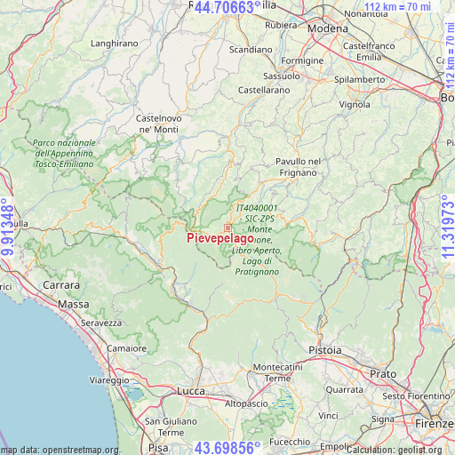
Pievepelago GPS coordinates[2]
44° 12' 17.1" North, 10° 36' 59.76" East
| Map corner | latitude | longitude |
|---|---|---|
| Upper-left | 44.70663°, | 9.91348° |
| Center: | 44.20475°, | 10.6166° |
| Lower-right: | 43.69856°, | 11.31973° |
| Map W x H: | 112.1×112.1 km | = 69.7×69.7mi |
| max Lat: | 47.04031° ⇑52.8% North |
| Pievepelago: | 44.20475° |
| min Lat: | ⇓47.2% South 35.50142° |
| min Long | Pievepelago | max Long |
| 6.69888° | 10.6166° | 18.48682° |
| W 38.3%⇐ | ⇒61.7% E |
Elevation
Elevation of Pievepelago is 781 m = 2562 ft, and this is 474.3 m = 1556 ft above average elevation for this country.
| Max E: |
2085 m = 6841 ft | 7.6% |
| Pievepelago | 781 m 2562 ft | |
| Avg. | 306.7 m = 1006 ft | |
Min E: |
-4 m = -13 ft | 92.4% |
See also: Italy elevation on elevation.city.
Geographical zone
Pievepelago is located in North temperate zone (between Tropic of Cancer and the Arctic Circle). Distance of this Northern Tropic circle is 2309.2 km =1434.9 mi to South.| Distance of | km | miles | from Pievepelago |
|---|---|---|---|
| North Pole | 5092 | 3164 | to North |
| Arctic Circle | 2486.1 | 1544.8 | to North |
| Tropic Cancer | 2309.2 | 1434.9 | to South |
| Equator | 4915.1 | 3054.1 | to South |


Nearby cities:
15 places around Pievepelago: (largest is in red/bold)
• Abetone
7.6 km =4.7 mi,  149°
149°
• Castiglione di Garfagnana
17.3 km =10.7 mi,  250°
250°
• Coreglia Antelminelli
17.4 km =10.8 mi,  205°
205°
• Cutigliano
16.1 km =10 mi,  136°
136°
• Fanano
14.4 km =8.9 mi,  86°
86°
• Fiumalbo-Dogana
3.7 km =2.3 mi, 139°
• Fosciandora
16.1 km =10 mi,  231°
231°
• Frassinoro
10.6 km =6.6 mi,  340°
340°
• Lama
14.6 km =9.1 mi,  38°
38°
• Montecreto
9.3 km =5.8 mi,  60°
60°
• Montefiorino
16.6 km =10.3 mi,  1°
1°
• Palagano
13.2 km =8.2 mi,  10°
10°
• Polinago
17.9 km =11.1 mi,  29°
29°
• Riolunato
4.1 km =2.5 mi, 44°
• Sestola
12.8 km =8 mi,  77°
77°
Sources, notices
• [Note1] Compared only with cities in Italy existing in our database
• [Src1] Map data: © OpenStreetMap contributors (CC-BY-SA)
• [Src2] Other city data from geonames.org with taken over terms of usage.
• [Src3] Geographical zone / Annual Mean Temperature by Robert A. Rohde @ Wikipedia
