Sestola geodata
Sestola (Emilia-Romagna) is a seat of a third-order administrative division; located in Italy in Europe/Rome (GMT+2) time zone. With population of 1,229 people, there are 5866 cities with bigger population in this country. Compared to other cities in Italy, 52.5% of cities are located further ↑North; 60% of cities are located further →East and 97% of cities have lower elevation than Sestola. Note1


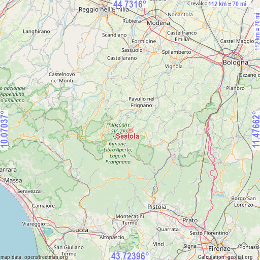
Sestola GPS coordinates[2]
44° 13' 47.784" North, 10° 46' 24.564" East
| Map corner | latitude | longitude |
|---|---|---|
| Upper-left | 44.7316°, | 10.07037° |
| Center: | 44.22994°, | 10.77349° |
| Lower-right: | 43.72396°, | 11.47662° |
| Map W x H: | 112×112 km | = 69.6×69.6mi |
| max Lat: | 47.04031° ⇑52.5% North |
| Sestola: | 44.22994° |
| min Lat: | ⇓47.5% South 35.50142° |
| min Long | Sestola | max Long |
| 6.69888° | 10.77349° | 18.48682° |
| W 40%⇐ | ⇒60% E |
Elevation
Elevation of Sestola is 993 m = 3258 ft, and this is 686.3 m = 2252 ft above average elevation for this country.
| Max E: |
2085 m = 6841 ft | 3% |
| Sestola | 993 m 3258 ft | |
| Avg. | 306.7 m = 1006 ft | |
Min E: |
-4 m = -13 ft | 97% |
See also: Italy elevation on elevation.city.
Geographical zone
Sestola is located in North temperate zone (between Tropic of Cancer and the Arctic Circle). Distance of this Northern Tropic circle is 2312 km =1436.6 mi to South.| Distance of | km | miles | from Sestola |
|---|---|---|---|
| North Pole | 5089.2 | 3162.3 | to North |
| Arctic Circle | 2483.3 | 1543.1 | to North |
| Tropic Cancer | 2312 | 1436.6 | to South |
| Equator | 4917.9 | 3055.8 | to South |


Nearby cities:
15 places around Sestola: (largest is in red/bold)
• Abetone
12.8 km =8 mi,  223°
223°
• Fanano
2.7 km =1.7 mi,  136°
136°
• Fiumalbo-Dogana
11.5 km =7.1 mi,  240°
240°
• Gaggio Montano
13.4 km =8.3 mi,  106°
106°
• Lama
9.3 km =5.8 mi,  338°
338°
• Lizzano in Belvedere
12.3 km =7.6 mi,  128°
128°
• Montecreto
4.8 km =3 mi,  291°
291°
• Montese
14.4 km =8.9 mi,  72°
72°
• Palagano
14.3 km =8.9 mi,  315°
315°
• Pavullo nel Frignano
12.5 km =7.8 mi,  23°
23°
• Pievepelago
12.8 km =8 mi,  257°
257°
• Polinago
13.3 km =8.3 mi, 343°
• Querciagrossa
10.1 km =6.3 mi,  25°
25°
• Riolunato
9.6 km =6 mi,  270°
270°
• Vidiciatico
10.5 km =6.5 mi, 129°
Sources, notices
• [Note1] Compared only with cities in Italy existing in our database
• [Src1] Map data: © OpenStreetMap contributors (CC-BY-SA)
• [Src2] Other city data from geonames.org with taken over terms of usage.
• [Src3] Geographical zone / Annual Mean Temperature by Robert A. Rohde @ Wikipedia
