Cutigliano geodata
Cutigliano (Tuscany) is a seat of a third-order administrative division; located in Italy in Europe/Rome (GMT+2) time zone. With population of 399 people, there are 10286 cities with bigger population in this country. Compared to other cities in Italy, 53.7% of cities are located further ↑North; 60.3% of cities are located further →East and 89.4% of cities have lower elevation than Cutigliano. Note1
Administrative division(s):
- Level 1: Tuscany
- Level 2: Provincia di Pistoia
- Level 3: Abetone Cutigliano


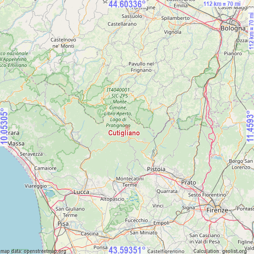
Cutigliano GPS coordinates[2]
44° 6' 2.124" North, 10° 45' 22.212" East
| Map corner | latitude | longitude |
|---|---|---|
| Upper-left | 44.60336°, | 10.05305° |
| Center: | 44.10059°, | 10.75617° |
| Lower-right: | 43.59351°, | 11.4593° |
| Map W x H: | 112.3×112.3 km | = 69.8×69.8mi |
| max Lat: | 47.04031° ⇑53.7% North |
| Cutigliano: | 44.10059° |
| min Lat: | ⇓46.3% South 35.50142° |
| min Long | Cutigliano | max Long |
| 6.69888° | 10.75617° | 18.48682° |
| W 39.7%⇐ | ⇒60.3% E |
Elevation
Elevation of Cutigliano is 704 m = 2310 ft, and this is 397.3 m = 1303 ft above average elevation for this country.
| Max E: |
2085 m = 6841 ft | 10.6% |
| Cutigliano | 704 m 2310 ft | |
| Avg. | 306.7 m = 1006 ft | |
Min E: |
-4 m = -13 ft | 89.4% |
See also: Italy elevation on elevation.city.
Geographical zone
Cutigliano is located in North temperate zone (between Tropic of Cancer and the Arctic Circle). Distance of this Northern Tropic circle is 2297.6 km =1427.7 mi to South.| Distance of | km | miles | from Cutigliano |
|---|---|---|---|
| North Pole | 5103.5 | 3171.2 | to North |
| Arctic Circle | 2497.6 | 1551.9 | to North |
| Tropic Cancer | 2297.6 | 1427.7 | to South |
| Equator | 4903.5 | 3046.9 | to South |


Nearby cities:
15 places around Cutigliano: (largest is in red/bold)
• Abetone
8.9 km =5.5 mi,  304°
304°
• Campo Tizzoro
10.2 km =6.3 mi,  131°
131°
• Cireglio
14.4 km =8.9 mi,  146°
146°
• Fanano
12.8 km =8 mi,  14°
14°
• Fiumalbo-Dogana
12.3 km =7.6 mi,  315°
315°
• Gavinana
7.4 km =4.6 mi, 134°
• Lizzano in Belvedere
12.9 km =8 mi,  58°
58°
• Molino del Pallone
16.4 km =10.2 mi,  90°
90°
• Montecreto
16.5 km =10.3 mi,  349°
349°
• Pievepelago
16.1 km =10 mi, 316°
• Piteglio
8.1 km =5 mi,  174°
174°
• Riolunato
16.7 km =10.4 mi,  330°
330°
• San Marcello Pistoiese
5.8 km =3.6 mi, 148°
• Sestola
14.4 km =8.9 mi, 5°
• Vidiciatico
12.3 km =7.6 mi,  50°
50°
Sources, notices
• [Note1] Compared only with cities in Italy existing in our database
• [Src1] Map data: © OpenStreetMap contributors (CC-BY-SA)
• [Src2] Other city data from geonames.org with taken over terms of usage.
• [Src3] Geographical zone / Annual Mean Temperature by Robert A. Rohde @ Wikipedia
