Pavia geodata
Pavia (Lombardy) is a seat of a second-order administrative division; located in Italy in Europe/Rome (GMT+2) time zone. With population of 65,734 people, there are 77 cities with bigger population in this country. Compared to other cities in Italy, 64.7% of cities are located further ↓South; 78.7% of cities are located further →East and 73.3% of cities have higher elevation than Pavia. Note1


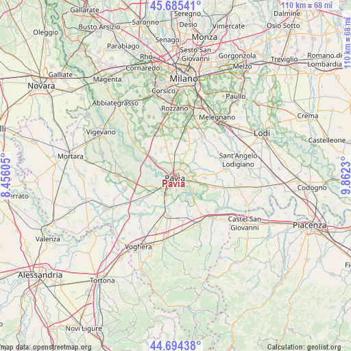
Pavia GPS coordinates[2]
45° 11' 31.38" North, 9° 9' 33.012" East
| Map corner | latitude | longitude |
|---|---|---|
| Upper-left | 45.68541°, | 8.45605° |
| Center: | 45.19205°, | 9.15917° |
| Lower-right: | 44.69438°, | 9.8623° |
| Map W x H: | 110.2×110.2 km | = 68.5×68.5mi |
| max Lat: | 47.04031° ⇑35.3% North |
| Pavia: | 45.19205° |
| min Lat: | ⇓64.7% South 35.50142° |
| min Long | Pavia | max Long |
| 6.69888° | 9.15917° | 18.48682° |
| W 21.3%⇐ | ⇒78.7% E |
Elevation
Elevation of Pavia is 82 m = 269 ft, and this is 224.7 m = 737 ft below average elevation for this country.
| Max E: |
2085 m = 6841 ft | 73.3% |
| Avg. | 306.7 m = 1006 ft | |
| Pavia | 82 m = 269 ft | |
Min E: |
-4 m = -13 ft | 26.7% |
See also: Pavia elevation on elevation.city.
Geographical zone
Pavia is located in North temperate zone (between Tropic of Cancer and the Arctic Circle). Distance of this North polar circle is 2376.3 km =1476.6 mi to North.| Distance of | km | miles | from Pavia |
|---|---|---|---|
| North Pole | 4982.2 | 3095.8 | to North |
| Arctic Circle | 2376.3 | 1476.6 | to North |
| Tropic Cancer | 2419 | 1503.1 | to South |
| Equator | 5024.9 | 3122.3 | to South |


Nearby cities:
15 places around Pavia: (largest is in red/bold)
• Bivio Cava Manara
6.3 km =3.9 mi,  208°
208°
• Borgarello
5.6 km =3.5 mi,  344°
344°
• Cascine Calderari
5.1 km =3.2 mi,  329°
329°
• Cava Manara
7 km =4.3 mi, 214°
• Certosa di Pavia
7.2 km =4.5 mi, 343°
• Fossarmato
4.8 km =3 mi,  87°
87°
• Madonna
5.2 km =3.2 mi, 211°
• Rotta
3.5 km =2.2 mi,  197°
197°
• San Genesio ed Uniti
5 km =3.1 mi,  19°
19°
• San Martino Siccomario
3.5 km =2.2 mi, 204°
• Sant'Alessio Con Vialone
6.2 km =3.9 mi,  57°
57°
• Torre d'Isola
7.1 km =4.4 mi,  293°
293°
• Torre del Mangano
7 km =4.3 mi, 341°
• Travacò Siccomario
4.8 km =3 mi,  179°
179°
• Valle Salimbene
6.3 km =3.9 mi,  110°
110°
Sources, notices
• [Note1] Compared only with cities in Italy existing in our database
• [Src1] Map data: © OpenStreetMap contributors (CC-BY-SA)
• [Src2] Other city data from geonames.org with taken over terms of usage.
• [Src3] Geographical zone / Annual Mean Temperature by Robert A. Rohde @ Wikipedia
