Certosa di Pavia geodata
Certosa di Pavia (Lombardy) is a seat of a third-order administrative division; located in Italy in Europe/Rome (GMT+2) time zone. With population of 3,320 people, there are 2823 cities with bigger population in this country. Compared to other cities in Italy, 66.3% of cities are located further ↓South; 79% of cities are located further →East and 72% of cities have higher elevation than Certosa di Pavia. Note1


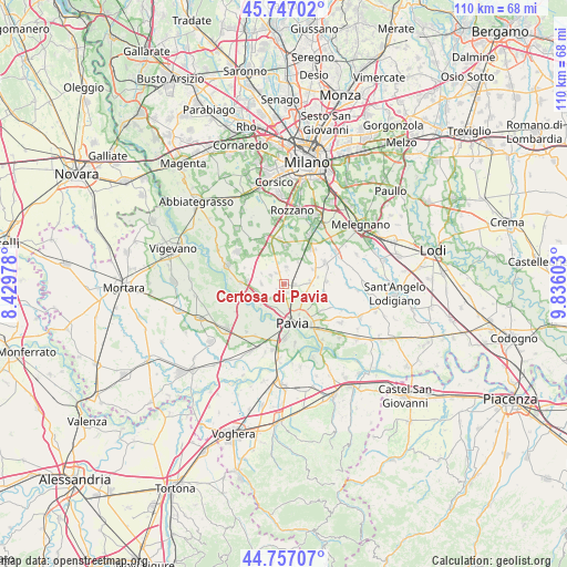
Certosa di Pavia GPS coordinates[2]
45° 15' 15.12" North, 9° 7' 58.44" East
| Map corner | latitude | longitude |
|---|---|---|
| Upper-left | 45.74702°, | 8.42978° |
| Center: | 45.2542°, | 9.1329° |
| Lower-right: | 44.75707°, | 9.83603° |
| Map W x H: | 110.1×110.1 km | = 68.4×68.4mi |
| max Lat: | 47.04031° ⇑33.7% North |
| Certosa di Pavia: | 45.2542° |
| min Lat: | ⇓66.3% South 35.50142° |
| min Long | Certosa di Pavi | max Long |
| 6.69888° | 9.1329° | 18.48682° |
| W 21%⇐ | ⇒79% E |
Elevation
Elevation of Certosa di Pavia is 88 m = 289 ft, and this is 218.7 m = 718 ft below average elevation for this country.
| Max E: |
2085 m = 6841 ft | 72% |
| Avg. | 306.7 m = 1006 ft | |
| Certosa di Pavia | 88 m = 289 ft | |
Min E: |
-4 m = -13 ft | 28% |
See also: Italy elevation on elevation.city.
Geographical zone
Certosa di Pavia is located in North temperate zone (between Tropic of Cancer and the Arctic Circle). Distance of this North polar circle is 2369.4 km =1472.3 mi to North.| Distance of | km | miles | from Certosa di Pavia |
|---|---|---|---|
| North Pole | 4975.3 | 3091.5 | to North |
| Arctic Circle | 2369.4 | 1472.3 | to North |
| Tropic Cancer | 2425.9 | 1507.4 | to South |
| Equator | 5031.8 | 3126.6 | to South |


Nearby cities:
15 places around Certosa di Pavia: (largest is in red/bold)
• Battuda
4.9 km =3 mi,  297°
297°
• Borgarello
1.6 km =1 mi,  158°
158°
• Cascine Calderari
2.6 km =1.6 mi,  191°
191°
• Casottole
5.9 km =3.7 mi,  240°
240°
• Giovenzano
2.5 km =1.6 mi,  328°
328°
• Giussago
3.4 km =2.1 mi,  9°
9°
• Guinzano
2 km =1.2 mi,  81°
81°
• Marcignago
4.2 km =2.6 mi,  268°
268°
• Rognano
5.1 km =3.2 mi,  318°
318°
• San Genesio ed Uniti
4.3 km =2.7 mi,  121°
121°
• Torre del Mangano
0.3 km =0.2 mi,  219°
219°
• Torriano
1.3 km =0.8 mi,  309°
309°
• Turago Bordone
5.1 km =3.2 mi,  32°
32°
• Vellezzo Bellini
3 km =1.9 mi, 304°
• Zeccone
5.4 km =3.4 mi,  85°
85°
Sources, notices
• [Note1] Compared only with cities in Italy existing in our database
• [Src1] Map data: © OpenStreetMap contributors (CC-BY-SA)
• [Src2] Other city data from geonames.org with taken over terms of usage.
• [Src3] Geographical zone / Annual Mean Temperature by Robert A. Rohde @ Wikipedia
