Borgarello geodata
Borgarello (Lombardy) is a seat of a third-order administrative division; located in Italy in Europe/Rome (GMT+2) time zone. With population of 2,485 people, there are 3545 cities with bigger population in this country. Compared to other cities in Italy, 65.9% of cities are located further ↓South; 79% of cities are located further →East and 72.5% of cities have higher elevation than Borgarello. Note1


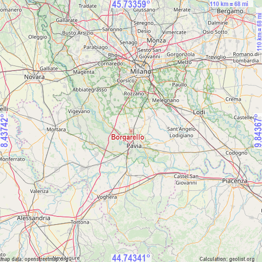
Borgarello GPS coordinates[2]
45° 14' 26.376" North, 9° 8' 25.98" East
| Map corner | latitude | longitude |
|---|---|---|
| Upper-left | 45.73359°, | 8.43742° |
| Center: | 45.24066°, | 9.14055° |
| Lower-right: | 44.74341°, | 9.84367° |
| Map W x H: | 110.1×110.1 km | = 68.4×68.4mi |
| max Lat: | 47.04031° ⇑34.1% North |
| Borgarello: | 45.24066° |
| min Lat: | ⇓65.9% South 35.50142° |
| min Long | Borgarello | max Long |
| 6.69888° | 9.14055° | 18.48682° |
| W 21%⇐ | ⇒79% E |
Elevation
Elevation of Borgarello is 85 m = 279 ft, and this is 221.7 m = 727 ft below average elevation for this country.
| Max E: |
2085 m = 6841 ft | 72.5% |
| Avg. | 306.7 m = 1006 ft | |
| Borgarello | 85 m = 279 ft | |
Min E: |
-4 m = -13 ft | 27.5% |
See also: Italy elevation on elevation.city.
Geographical zone
Borgarello is located in North temperate zone (between Tropic of Cancer and the Arctic Circle). Distance of this North polar circle is 2370.9 km =1473.2 mi to North.| Distance of | km | miles | from Borgarello |
|---|---|---|---|
| North Pole | 4976.8 | 3092.4 | to North |
| Arctic Circle | 2370.9 | 1473.2 | to North |
| Tropic Cancer | 2424.4 | 1506.5 | to South |
| Equator | 5030.3 | 3125.7 | to South |


Nearby cities:
15 places around Borgarello: (largest is in red/bold)
• Cascine Calderari
1.5 km =0.9 mi,  226°
226°
• Casottole
5.9 km =3.7 mi,  256°
256°
• Certosa di Pavia
1.6 km =1 mi,  338°
338°
• Giovenzano
4.1 km =2.5 mi,  332°
332°
• Giussago
4.8 km =3 mi,  359°
359°
• Guinzano
2.3 km =1.4 mi,  38°
38°
• Marcignago
5 km =3.1 mi,  286°
286°
• Pavia
5.6 km =3.5 mi,  164°
164°
• San Genesio ed Uniti
3.2 km =2 mi,  103°
103°
• Torre d'Isola
5.6 km =3.5 mi,  243°
243°
• Torre del Mangano
1.5 km =0.9 mi, 328°
• Torriano
2.8 km =1.7 mi, 325°
• Turago Bordone
6.2 km =3.9 mi,  20°
20°
• Vellezzo Bellini
4.5 km =2.8 mi,  315°
315°
• Zeccone
5.1 km =3.2 mi,  68°
68°
Sources, notices
• [Note1] Compared only with cities in Italy existing in our database
• [Src1] Map data: © OpenStreetMap contributors (CC-BY-SA)
• [Src2] Other city data from geonames.org with taken over terms of usage.
• [Src3] Geographical zone / Annual Mean Temperature by Robert A. Rohde @ Wikipedia
