Parre geodata
Parre (Lombardy) is a seat of a third-order administrative division; located in Italy in Europe/Rome (GMT+2) time zone. With population of 2,651 people, there are 3369 cities with bigger population in this country. Compared to other cities in Italy, 88.4% of cities are located further ↓South; 68.9% of cities are located further →East and 84.4% of cities have lower elevation than Parre. Note1


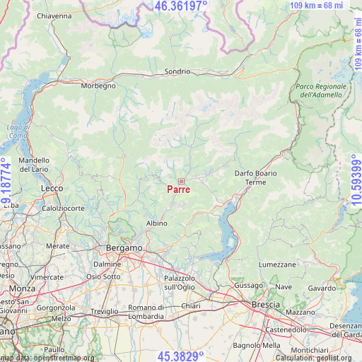
Parre GPS coordinates[2]
45° 52' 28.524" North, 9° 53' 27.096" East
| Map corner | latitude | longitude |
|---|---|---|
| Upper-left | 46.36197°, | 9.18774° |
| Center: | 45.87459°, | 9.89086° |
| Lower-right: | 45.3829°, | 10.59399° |
| Map W x H: | 108.9×108.9 km | = 67.7×67.7mi |
| max Lat: | 47.04031° ⇑11.6% North |
| Parre: | 45.87459° |
| min Lat: | ⇓88.4% South 35.50142° |
| min Long | Parre | max Long |
| 6.69888° | 9.89086° | 18.48682° |
| W 31.1%⇐ | ⇒68.9% E |
Elevation
Elevation of Parre is 599 m = 1965 ft, and this is 292.3 m = 959 ft above average elevation for this country.
| Max E: |
2085 m = 6841 ft | 15.6% |
| Parre | 599 m 1965 ft | |
| Avg. | 306.7 m = 1006 ft | |
Min E: |
-4 m = -13 ft | 84.4% |
See also: Italy elevation on elevation.city.
Geographical zone
Parre is located in North temperate zone (between Tropic of Cancer and the Arctic Circle). Distance of this North polar circle is 2300.4 km =1429.4 mi to North.| Distance of | km | miles | from Parre |
|---|---|---|---|
| North Pole | 4906.3 | 3048.6 | to North |
| Arctic Circle | 2300.4 | 1429.4 | to North |
| Tropic Cancer | 2494.9 | 1550.3 | to South |
| Equator | 5100.8 | 3169.5 | to South |


Nearby cities:
15 places around Parre: (largest is in red/bold)
• Casnigo
7.1 km =4.4 mi,  194°
194°
• Cazzano Sant'Andrea
7.1 km =4.4 mi,  183°
183°
• Clusone
4.5 km =2.8 mi,  72°
72°
• Colzate
6.9 km =4.3 mi,  202°
202°
• Gandino
7.1 km =4.4 mi, 175°
• Gorno
4 km =2.5 mi,  250°
250°
• Oltressenda Alta
6.2 km =3.9 mi,  42°
42°
• Oneta
5.5 km =3.4 mi,  266°
266°
• Piario
3.7 km =2.3 mi,  49°
49°
• Ponte Nossa
1.1 km =0.7 mi,  210°
210°
• Premolo
1.3 km =0.8 mi, 248°
• San Lorenzo di Rovetta
6.6 km =4.1 mi,  85°
85°
• Villa d'Ogna
4.6 km =2.9 mi, 42°
• Villa d'Oneta
5.6 km =3.5 mi, 265°
• Villassio
3.8 km =2.4 mi, 250°
Sources, notices
• [Note1] Compared only with cities in Italy existing in our database
• [Src1] Map data: © OpenStreetMap contributors (CC-BY-SA)
• [Src2] Other city data from geonames.org with taken over terms of usage.
• [Src3] Geographical zone / Annual Mean Temperature by Robert A. Rohde @ Wikipedia
