Palomonte geodata
Palomonte (Campania) is a seat of a third-order administrative division; located in Italy in Europe/Rome (GMT+2) time zone. With population of 230 people, there are 10980 cities with bigger population in this country. Compared to other cities in Italy, 82.8% of cities are located further ↑North; 89.5% of cities are located further ←West and 80.9% of cities have lower elevation than Palomonte. Note1


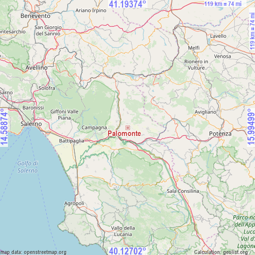
Palomonte GPS coordinates[2]
40° 39' 45.036" North, 15° 17' 30.696" East
| Map corner | latitude | longitude |
|---|---|---|
| Upper-left | 41.19374°, | 14.58874° |
| Center: | 40.66251°, | 15.29186° |
| Lower-right: | 40.12702°, | 15.99499° |
| Map W x H: | 118.6×118.6 km | = 73.7×73.7mi |
| max Lat: | 47.04031° ⇑82.8% North |
| Palomonte: | 40.66251° |
| min Lat: | ⇓17.2% South 35.50142° |
| min Long | Palomonte | max Long |
| 6.69888° | 15.29186° | 18.48682° |
| W 89.5%⇐ | ⇒10.5% E |
Elevation
Elevation of Palomonte is 538 m = 1765 ft, and this is 231.3 m = 759 ft above average elevation for this country.
| Max E: |
2085 m = 6841 ft | 19.1% |
| Palomonte | 538 m 1765 ft | |
| Avg. | 306.7 m = 1006 ft | |
Min E: |
-4 m = -13 ft | 80.9% |
See also: Italy elevation on elevation.city.
Geographical zone
Palomonte is located in North temperate zone (between Tropic of Cancer and the Arctic Circle). Distance of this Northern Tropic circle is 1915.3 km =1190.1 mi to South.| Distance of | km | miles | from Palomonte |
|---|---|---|---|
| North Pole | 5485.8 | 3408.7 | to North |
| Arctic Circle | 2879.9 | 1789.5 | to North |
| Tropic Cancer | 1915.3 | 1190.1 | to South |
| Equator | 4521.2 | 2809.3 | to South |


Nearby cities:
15 places around Palomonte: (largest is in red/bold)
• Ariola
12.6 km =7.8 mi,  107°
107°
• Buccino
8.1 km =5 mi, 110°
• Calabritto
14.6 km =9.1 mi,  336°
336°
• Colliano
6.7 km =4.2 mi,  358°
358°
• Contursi Terme
4.5 km =2.8 mi,  252°
252°
• Laviano
13.8 km =8.6 mi,  5°
5°
• Oliveto Citra
5.8 km =3.6 mi,  302°
302°
• Postiglione
12.6 km =7.8 mi,  203°
203°
• Puglietta
11.8 km =7.3 mi,  263°
263°
• San Gregorio Magno
9.1 km =5.7 mi,  91°
91°
• Scalo Romagnano al Monte
14.4 km =8.9 mi, 113°
• Senerchia
11.4 km =7.1 mi,  320°
320°
• Serre
12.6 km =7.8 mi,  225°
225°
• Sicignano degli Alburni
11.6 km =7.2 mi,  174°
174°
• Valva
8.7 km =5.4 mi,  346°
346°
Sources, notices
• [Note1] Compared only with cities in Italy existing in our database
• [Src1] Map data: © OpenStreetMap contributors (CC-BY-SA)
• [Src2] Other city data from geonames.org with taken over terms of usage.
• [Src3] Geographical zone / Annual Mean Temperature by Robert A. Rohde @ Wikipedia
