Puglietta geodata
Puglietta (Campania) is a populated place; located in Italy in Europe/Rome (GMT+2) time zone. With population of 860 people, there are 7361 cities with bigger population in this country. Compared to other cities in Italy, 82.9% of cities are located further ↑North; 88.5% of cities are located further ←West and 67.4% of cities have lower elevation than Puglietta. Note1


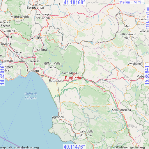
Puglietta GPS coordinates[2]
40° 39' 1.26" North, 15° 9' 11.808" East
| Map corner | latitude | longitude |
|---|---|---|
| Upper-left | 41.18168°, | 14.45016° |
| Center: | 40.65035°, | 15.15328° |
| Lower-right: | 40.11476°, | 15.85641° |
| Map W x H: | 118.6×118.6 km | = 73.7×73.7mi |
| max Lat: | 47.04031° ⇑82.9% North |
| Puglietta: | 40.65035° |
| min Lat: | ⇓17.1% South 35.50142° |
| min Long | Puglietta | max Long |
| 6.69888° | 15.15328° | 18.48682° |
| W 88.5%⇐ | ⇒11.5% E |
Elevation
Elevation of Puglietta is 367 m = 1204 ft, and this is 60.3 m = 198 ft above average elevation for this country.
| Max E: |
2085 m = 6841 ft | 32.6% |
| Puglietta | 367 m 1204 ft | |
| Avg. | 306.7 m = 1006 ft | |
Min E: |
-4 m = -13 ft | 67.4% |
See also: Italy elevation on elevation.city.
Geographical zone
Puglietta is located in North temperate zone (between Tropic of Cancer and the Arctic Circle). Distance of this Northern Tropic circle is 1914 km =1189.3 mi to South.| Distance of | km | miles | from Puglietta |
|---|---|---|---|
| North Pole | 5487.2 | 3409.6 | to North |
| Arctic Circle | 2881.3 | 1790.4 | to North |
| Tropic Cancer | 1914 | 1189.3 | to South |
| Equator | 4519.9 | 2808.5 | to South |


Nearby cities:
15 places around Puglietta: (largest is in red/bold)
• Acerno
12.7 km =7.9 mi,  320°
320°
• Ariano
10.9 km =6.8 mi,  273°
273°
• Campagna
4.3 km =2.7 mi,  294°
294°
• Contursi Terme
7.5 km =4.7 mi,  90°
90°
• Eboli
8.9 km =5.5 mi,  245°
245°
• Monticelli
11.5 km =7.1 mi, 269°
• Olevano sul Tusciano
11 km =6.8 mi, 273°
• Oliveto Citra
8.1 km =5 mi,  56°
56°
• Palomonte
11.8 km =7.3 mi,  83°
83°
• Postiglione
12.2 km =7.6 mi,  146°
146°
• Quadrivio
5.1 km =3.2 mi,  236°
236°
• Salitto-Valle
11.4 km =7.1 mi,  283°
283°
• Santa Lucia-Santa Maria la Nova
6.6 km =4.1 mi, 249°
• Senerchia
11 km =6.8 mi,  23°
23°
• Serre
8 km =5 mi,  160°
160°
Sources, notices
• [Note1] Compared only with cities in Italy existing in our database
• [Src1] Map data: © OpenStreetMap contributors (CC-BY-SA)
• [Src2] Other city data from geonames.org with taken over terms of usage.
• [Src3] Geographical zone / Annual Mean Temperature by Robert A. Rohde @ Wikipedia
