Postiglione geodata
Postiglione (Campania) is a seat of a third-order administrative division; located in Italy in Europe/Rome (GMT+2) time zone. With population of 1,080 people, there are 6373 cities with bigger population in this country. Compared to other cities in Italy, 83.8% of cities are located further ↑North; 89.1% of cities are located further ←West and 86.2% of cities have lower elevation than Postiglione. Note1


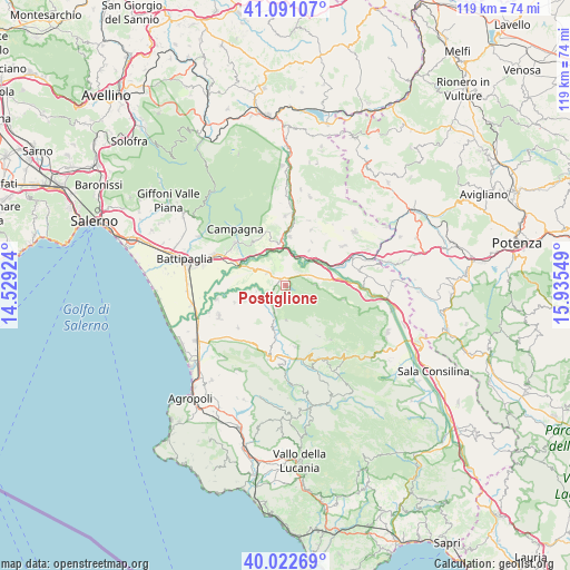
Postiglione GPS coordinates[2]
40° 33' 32.436" North, 15° 13' 56.496" East
| Map corner | latitude | longitude |
|---|---|---|
| Upper-left | 41.09107°, | 14.52924° |
| Center: | 40.55901°, | 15.23236° |
| Lower-right: | 40.02269°, | 15.93549° |
| Map W x H: | 118.8×118.8 km | = 73.8×73.8mi |
| max Lat: | 47.04031° ⇑83.8% North |
| Postiglione: | 40.55901° |
| min Lat: | ⇓16.2% South 35.50142° |
| min Long | Postiglione | max Long |
| 6.69888° | 15.23236° | 18.48682° |
| W 89.1%⇐ | ⇒10.9% E |
Elevation
Elevation of Postiglione is 637 m = 2090 ft, and this is 330.3 m = 1084 ft above average elevation for this country.
| Max E: |
2085 m = 6841 ft | 13.8% |
| Postiglione | 637 m 2090 ft | |
| Avg. | 306.7 m = 1006 ft | |
Min E: |
-4 m = -13 ft | 86.2% |
See also: Italy elevation on elevation.city.
Geographical zone
Postiglione is located in North temperate zone (between Tropic of Cancer and the Arctic Circle). Distance of this Northern Tropic circle is 1903.8 km =1183 mi to South.| Distance of | km | miles | from Postiglione |
|---|---|---|---|
| North Pole | 5497.3 | 3415.9 | to North |
| Arctic Circle | 2891.4 | 1796.6 | to North |
| Tropic Cancer | 1903.8 | 1183 | to South |
| Equator | 4509.7 | 2802.2 | to South |


Nearby cities:
15 places around Postiglione: (largest is in red/bold)
• Albanella
13.3 km =8.3 mi,  228°
228°
• Altavilla Silentina
9.1 km =5.7 mi,  249°
249°
• Aquara
12.9 km =8 mi,  171°
171°
• Castelcivita
7.3 km =4.5 mi,  179°
179°
• Cerrelli
11.3 km =7 mi, 252°
• Controne
5.9 km =3.7 mi,  203°
203°
• Contursi Terme
10.2 km =6.3 mi,  4°
4°
• Oliveto Citra
14.6 km =9.1 mi, 0°
• Ottati
12.8 km =8 mi,  146°
146°
• Palomonte
12.6 km =7.8 mi,  23°
23°
• Petina
12.3 km =7.6 mi,  104°
104°
• Puglietta
12.2 km =7.6 mi,  326°
326°
• Quadrivio
13.1 km =8.1 mi,  303°
303°
• Serre
4.7 km =2.9 mi, 303°
• Sicignano degli Alburni
6.2 km =3.9 mi,  90°
90°
Sources, notices
• [Note1] Compared only with cities in Italy existing in our database
• [Src1] Map data: © OpenStreetMap contributors (CC-BY-SA)
• [Src2] Other city data from geonames.org with taken over terms of usage.
• [Src3] Geographical zone / Annual Mean Temperature by Robert A. Rohde @ Wikipedia
