Pallare geodata
Pallare (Liguria) is a seat of a third-order administrative division; located in Italy in Europe/Rome (GMT+2) time zone. With population of 693 people, there are 8345 cities with bigger population in this country. Compared to other cities in Italy, 51.6% of cities are located further ↑North; 90.3% of cities are located further →East and 70% of cities have lower elevation than Pallare. Note1


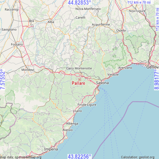
Pallare GPS coordinates[2]
44° 19' 39.72" North, 8° 16' 43.104" East
| Map corner | latitude | longitude |
|---|---|---|
| Upper-left | 44.82853°, | 7.57552° |
| Center: | 44.3277°, | 8.27864° |
| Lower-right: | 43.82256°, | 8.98177° |
| Map W x H: | 111.9×111.9 km | = 69.5×69.5mi |
| max Lat: | 47.04031° ⇑51.6% North |
| Pallare: | 44.3277° |
| min Lat: | ⇓48.4% South 35.50142° |
| min Long | Pallare | max Long |
| 6.69888° | 8.27864° | 18.48682° |
| W 9.7%⇐ | ⇒90.3% E |
Elevation
Elevation of Pallare is 394 m = 1293 ft, and this is 87.3 m = 286 ft above average elevation for this country.
| Max E: |
2085 m = 6841 ft | 30% |
| Pallare | 394 m 1293 ft | |
| Avg. | 306.7 m = 1006 ft | |
Min E: |
-4 m = -13 ft | 70% |
See also: Italy elevation on elevation.city.
Geographical zone
Pallare is located in North temperate zone (between Tropic of Cancer and the Arctic Circle). Distance of this Northern Tropic circle is 2322.9 km =1443.4 mi to South.| Distance of | km | miles | from Pallare |
|---|---|---|---|
| North Pole | 5078.3 | 3155.5 | to North |
| Arctic Circle | 2472.4 | 1536.3 | to North |
| Tropic Cancer | 2322.9 | 1443.4 | to South |
| Equator | 4928.8 | 3062.6 | to South |


Nearby cities:
15 places around Pallare: (largest is in red/bold)
• Altare
4.5 km =2.8 mi,  78°
78°
• Bormida
6.6 km =4.1 mi,  213°
213°
• Cairo Montenotte
7.8 km =4.8 mi,  359°
359°
• Carcare
3.1 km =1.9 mi,  17°
17°
• Cengio Alto
9 km =5.6 mi,  314°
314°
• Cosseria
5.7 km =3.5 mi,  321°
321°
• Ferrania
4.7 km =2.9 mi,  42°
42°
• Mallare
4.5 km =2.8 mi,  161°
161°
• Millesimo
7.4 km =4.6 mi, 306°
• Murialdo
8.9 km =5.5 mi,  262°
262°
• Osiglia
8 km =5 mi,  230°
230°
• Piano
9 km =5.6 mi, 262°
• Plodio
3.8 km =2.4 mi, 319°
• Roccavignale
7.9 km =4.9 mi,  298°
298°
• Valzemola
9.3 km =5.8 mi, 295°
Sources, notices
• [Note1] Compared only with cities in Italy existing in our database
• [Src1] Map data: © OpenStreetMap contributors (CC-BY-SA)
• [Src2] Other city data from geonames.org with taken over terms of usage.
• [Src3] Geographical zone / Annual Mean Temperature by Robert A. Rohde @ Wikipedia
