Mallare geodata
Mallare (Liguria) is a seat of a third-order administrative division; located in Italy in Europe/Rome (GMT+2) time zone. With population of 792 people, there are 7691 cities with bigger population in this country. Compared to other cities in Italy, 52% of cities are located further ↑North; 90.1% of cities are located further →East and 75.9% of cities have lower elevation than Mallare. Note1


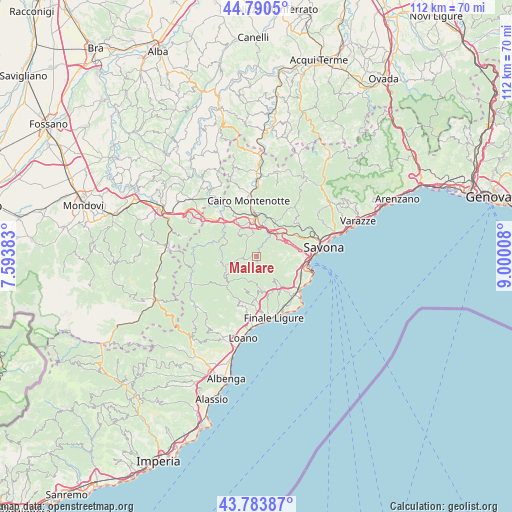
Mallare GPS coordinates[2]
44° 17' 21.624" North, 8° 17' 49.02" East
| Map corner | latitude | longitude |
|---|---|---|
| Upper-left | 44.7905°, | 7.59383° |
| Center: | 44.28934°, | 8.29695° |
| Lower-right: | 43.78387°, | 9.00008° |
| Map W x H: | 111.9×111.9 km | = 69.5×69.5mi |
| max Lat: | 47.04031° ⇑52% North |
| Mallare: | 44.28934° |
| min Lat: | ⇓48% South 35.50142° |
| min Long | Mallare | max Long |
| 6.69888° | 8.29695° | 18.48682° |
| W 9.9%⇐ | ⇒90.1% E |
Elevation
Elevation of Mallare is 464 m = 1522 ft, and this is 157.3 m = 516 ft above average elevation for this country.
| Max E: |
2085 m = 6841 ft | 24.1% |
| Mallare | 464 m 1522 ft | |
| Avg. | 306.7 m = 1006 ft | |
Min E: |
-4 m = -13 ft | 75.9% |
See also: Italy elevation on elevation.city.
Geographical zone
Mallare is located in North temperate zone (between Tropic of Cancer and the Arctic Circle). Distance of this Northern Tropic circle is 2318.6 km =1440.7 mi to South.| Distance of | km | miles | from Mallare |
|---|---|---|---|
| North Pole | 5082.5 | 3158.1 | to North |
| Arctic Circle | 2476.7 | 1538.9 | to North |
| Tropic Cancer | 2318.6 | 1440.7 | to South |
| Equator | 4924.5 | 3059.9 | to South |


Nearby cities:
15 places around Mallare: (largest is in red/bold)
• Altare
5.9 km =3.7 mi,  29°
29°
• Bormida
5.3 km =3.3 mi,  256°
256°
• Calice Ligure
9.4 km =5.8 mi,  180°
180°
• Carcare
7.3 km =4.5 mi,  355°
355°
• Feglino
8.2 km =5.1 mi,  164°
164°
• Ferrania
7.9 km =4.9 mi,  12°
12°
• Orco Feglino
8 km =5 mi, 164°
• Osiglia
7.7 km =4.8 mi, 263°
• Pallare
4.5 km =2.8 mi,  341°
341°
• Plodio
8.2 km =5.1 mi,  331°
331°
• Quiliano
9.3 km =5.8 mi,  88°
88°
• Rialto
7.5 km =4.7 mi,  202°
202°
• Sant'Ermete
9 km =5.6 mi,  114°
114°
• Valle di Vado
9.8 km =6.1 mi, 108°
• Vezzi Portio
8.6 km =5.3 mi,  140°
140°
Sources, notices
• [Note1] Compared only with cities in Italy existing in our database
• [Src1] Map data: © OpenStreetMap contributors (CC-BY-SA)
• [Src2] Other city data from geonames.org with taken over terms of usage.
• [Src3] Geographical zone / Annual Mean Temperature by Robert A. Rohde @ Wikipedia
