Osiglia geodata
Osiglia (Liguria) is a seat of a third-order administrative division; located in Italy in Europe/Rome (GMT+2) time zone. With population of 287 people, there are 10725 cities with bigger population in this country. Compared to other cities in Italy, 52% of cities are located further ↑North; 91% of cities are located further →East and 87.8% of cities have lower elevation than Osiglia. Note1


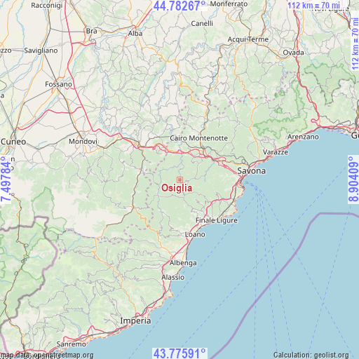
Osiglia GPS coordinates[2]
44° 16' 53.22" North, 8° 12' 3.456" East
| Map corner | latitude | longitude |
|---|---|---|
| Upper-left | 44.78267°, | 7.49784° |
| Center: | 44.28145°, | 8.20096° |
| Lower-right: | 43.77591°, | 8.90409° |
| Map W x H: | 111.9×111.9 km | = 69.5×69.5mi |
| max Lat: | 47.04031° ⇑52% North |
| Osiglia: | 44.28145° |
| min Lat: | ⇓48% South 35.50142° |
| min Long | Osiglia | max Long |
| 6.69888° | 8.20096° | 18.48682° |
| W 9%⇐ | ⇒91% E |
Elevation
Elevation of Osiglia is 669 m = 2195 ft, and this is 362.3 m = 1189 ft above average elevation for this country.
| Max E: |
2085 m = 6841 ft | 12.2% |
| Osiglia | 669 m 2195 ft | |
| Avg. | 306.7 m = 1006 ft | |
Min E: |
-4 m = -13 ft | 87.8% |
See also: Italy elevation on elevation.city.
Geographical zone
Osiglia is located in North temperate zone (between Tropic of Cancer and the Arctic Circle). Distance of this Northern Tropic circle is 2317.7 km =1440.2 mi to South.| Distance of | km | miles | from Osiglia |
|---|---|---|---|
| North Pole | 5083.4 | 3158.7 | to North |
| Arctic Circle | 2477.5 | 1539.4 | to North |
| Tropic Cancer | 2317.7 | 1440.2 | to South |
| Equator | 4923.6 | 3059.4 | to South |


Nearby cities:
15 places around Osiglia: (largest is in red/bold)
• Bormida
2.5 km =1.6 mi,  98°
98°
• Calizzano
8.3 km =5.2 mi,  232°
232°
• Castelnuovo di Ceva
9.9 km =6.2 mi,  324°
324°
• Cosseria
10 km =6.2 mi,  15°
15°
• Magliolo
10.6 km =6.6 mi,  158°
158°
• Mallare
7.7 km =4.8 mi,  83°
83°
• Massimino
10.5 km =6.5 mi,  281°
281°
• Millesimo
9.5 km =5.9 mi,  1°
1°
• Murialdo
4.7 km =2.9 mi,  326°
326°
• Pallare
8 km =5 mi,  50°
50°
• Piano
4.8 km =3 mi, 325°
• Plodio
8.9 km =5.5 mi, 24°
• Rialto
7.8 km =4.8 mi,  141°
141°
• Roccavignale
8.9 km =5.5 mi,  354°
354°
• Valzemola
9.4 km =5.8 mi, 346°
Sources, notices
• [Note1] Compared only with cities in Italy existing in our database
• [Src1] Map data: © OpenStreetMap contributors (CC-BY-SA)
• [Src2] Other city data from geonames.org with taken over terms of usage.
• [Src3] Geographical zone / Annual Mean Temperature by Robert A. Rohde @ Wikipedia
