Palazzo geodata
Palazzo (Umbria) is a populated place; located in Italy in Europe/Rome (GMT+2) time zone. With population of 1,817 people, there are 4464 cities with bigger population in this country. Compared to other cities in Italy, 62.6% of cities are located further ↑North; 63.1% of cities are located further ←West and 50.2% of cities have higher elevation than Palazzo. Note1


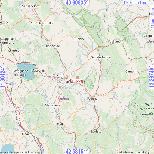
Palazzo GPS coordinates[2]
43° 5' 49.488" North, 12° 33' 51.696" East
| Map corner | latitude | longitude |
|---|---|---|
| Upper-left | 43.60835°, | 11.86124° |
| Center: | 43.09708°, | 12.56436° |
| Lower-right: | 42.58151°, | 13.26749° |
| Map W x H: | 114.2×114.2 km | = 71×71mi |
| max Lat: | 47.04031° ⇑62.6% North |
| Palazzo: | 43.09708° |
| min Lat: | ⇓37.4% South 35.50142° |
| min Long | Palazzo | max Long |
| 6.69888° | 12.56436° | 18.48682° |
| W 63.1%⇐ | ⇒36.9% E |
Elevation
Elevation of Palazzo is 234 m = 768 ft, and this is 72.7 m = 239 ft below average elevation for this country.
| Max E: |
2085 m = 6841 ft | 50.2% |
| Avg. | 306.7 m = 1006 ft | |
| Palazzo | 234 m = 768 ft | |
Min E: |
-4 m = -13 ft | 49.8% |
See also: Italy elevation on elevation.city.
Geographical zone
Palazzo is located in North temperate zone (between Tropic of Cancer and the Arctic Circle). Distance of this Northern Tropic circle is 2186 km =1358.3 mi to South.| Distance of | km | miles | from Palazzo |
|---|---|---|---|
| North Pole | 5215.1 | 3240.5 | to North |
| Arctic Circle | 2609.2 | 1621.3 | to North |
| Tropic Cancer | 2186 | 1358.3 | to South |
| Equator | 4791.9 | 2977.5 | to South |


Nearby cities:
15 places around Palazzo: (largest is in red/bold)
• Assisi
5.7 km =3.5 mi,  126°
126°
• Bastia umbra
3.9 km =2.4 mi,  202°
202°
• Brufa
8.8 km =5.5 mi,  239°
239°
• Castelnuovo
7.7 km =4.8 mi,  167°
167°
• Costano
6.4 km =4 mi, 202°
• Ospedalicchio
5.6 km =3.5 mi,  247°
247°
• Petrignano
2.7 km =1.7 mi,  283°
283°
• Rivotorto
7.5 km =4.7 mi,  142°
142°
• San Vitale
8.2 km =5.1 mi, 133°
• Sant'Egidio
6 km =3.7 mi, 275°
• Santa Maria degli Angeli
4.5 km =2.8 mi, 169°
• Torchiagina
3.5 km =2.2 mi,  316°
316°
• Tordandrea
6.8 km =4.2 mi,  185°
185°
• Valfabbrica
7.4 km =4.6 mi,  24°
24°
• Via Lippia
6.9 km =4.3 mi,  259°
259°
Sources, notices
• [Note1] Compared only with cities in Italy existing in our database
• [Src1] Map data: © OpenStreetMap contributors (CC-BY-SA)
• [Src2] Other city data from geonames.org with taken over terms of usage.
• [Src3] Geographical zone / Annual Mean Temperature by Robert A. Rohde @ Wikipedia
