Assisi geodata
Assisi (Umbria) is a seat of a third-order administrative division; located in Italy in Europe/Rome (GMT+2) time zone. With population of 3,732 people, there are 2543 cities with bigger population in this country. Compared to other cities in Italy, 62.8% of cities are located further ↑North; 64% of cities are located further ←West and 71.5% of cities have lower elevation than Assisi. Note1


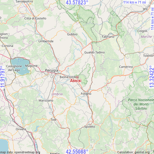
Assisi GPS coordinates[2]
43° 4' 0.156" North, 12° 37' 15.924" East
| Map corner | latitude | longitude |
|---|---|---|
| Upper-left | 43.57823°, | 11.91797° |
| Center: | 43.06671°, | 12.62109° |
| Lower-right: | 42.55088°, | 13.32422° |
| Map W x H: | 114.2×114.2 km | = 71×71mi |
| max Lat: | 47.04031° ⇑62.8% North |
| Assisi: | 43.06671° |
| min Lat: | ⇓37.2% South 35.50142° |
| min Long | Assisi | max Long |
| 6.69888° | 12.62109° | 18.48682° |
| W 64%⇐ | ⇒36% E |
Elevation
Elevation of Assisi is 410 m = 1345 ft, and this is 103.3 m = 339 ft above average elevation for this country.
| Max E: |
2085 m = 6841 ft | 28.5% |
| Assisi | 410 m 1345 ft | |
| Avg. | 306.7 m = 1006 ft | |
Min E: |
-4 m = -13 ft | 71.5% |
See also: Italy elevation on elevation.city.
Geographical zone
Assisi is located in North temperate zone (between Tropic of Cancer and the Arctic Circle). Distance of this Northern Tropic circle is 2182.7 km =1356.3 mi to South.| Distance of | km | miles | from Assisi |
|---|---|---|---|
| North Pole | 5218.5 | 3242.6 | to North |
| Arctic Circle | 2612.6 | 1623.4 | to North |
| Tropic Cancer | 2182.7 | 1356.3 | to South |
| Equator | 4788.6 | 2975.5 | to South |


Nearby cities:
15 places around Assisi: (largest is in red/bold)
• Bastia umbra
6.1 km =3.8 mi,  267°
267°
• Cannara
8.5 km =5.3 mi,  201°
201°
• Capitan Loreto
5.9 km =3.7 mi,  158°
158°
• Case Nuove
4.8 km =3 mi, 160°
• Castelnuovo
5.1 km =3.2 mi,  215°
215°
• Costano
7.5 km =4.7 mi,  250°
250°
• Ospedalicchio
9.9 km =6.2 mi,  277°
277°
• Palazzo
5.7 km =3.5 mi,  306°
306°
• Petrignano
8.2 km =5.1 mi,  299°
299°
• Rivotorto
2.5 km =1.6 mi,  180°
180°
• San Vitale
2.6 km =1.6 mi,  148°
148°
• Santa Maria degli Angeli
3.9 km =2.4 mi, 253°
• Spello
9.1 km =5.7 mi, 156°
• Torchiagina
9.2 km =5.7 mi, 309°
• Tordandrea
6.3 km =3.9 mi,  237°
237°
Sources, notices
• [Note1] Compared only with cities in Italy existing in our database
• [Src1] Map data: © OpenStreetMap contributors (CC-BY-SA)
• [Src2] Other city data from geonames.org with taken over terms of usage.
• [Src3] Geographical zone / Annual Mean Temperature by Robert A. Rohde @ Wikipedia
