Rivotorto geodata
Rivotorto (Umbria) is a populated place; located in Italy in Europe/Rome (GMT+2) time zone. With population of 1,425 people, there are 5307 cities with bigger population in this country. Compared to other cities in Italy, 63% of cities are located further ↑North; 64% of cities are located further ←West and 51.3% of cities have higher elevation than Rivotorto. Note1


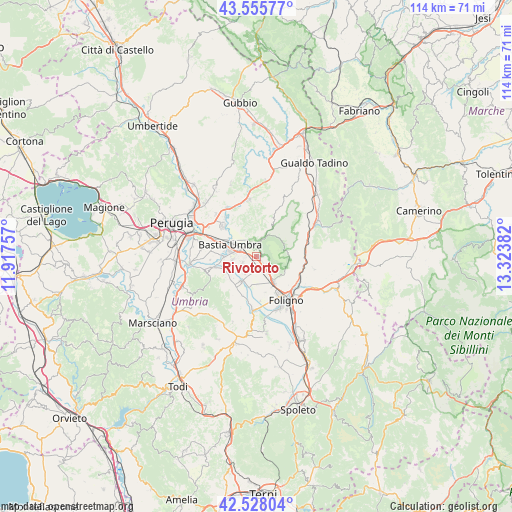
Rivotorto GPS coordinates[2]
43° 2' 38.616" North, 12° 37' 14.484" East
| Map corner | latitude | longitude |
|---|---|---|
| Upper-left | 43.55577°, | 11.91757° |
| Center: | 43.04406°, | 12.62069° |
| Lower-right: | 42.52804°, | 13.32382° |
| Map W x H: | 114.3×114.3 km | = 71×71mi |
| max Lat: | 47.04031° ⇑63% North |
| Rivotorto: | 43.04406° |
| min Lat: | ⇓37% South 35.50142° |
| min Long | Rivotorto | max Long |
| 6.69888° | 12.62069° | 18.48682° |
| W 64%⇐ | ⇒36% E |
Elevation
Elevation of Rivotorto is 226 m = 741 ft, and this is 80.7 m = 265 ft below average elevation for this country.
| Max E: |
2085 m = 6841 ft | 51.3% |
| Avg. | 306.7 m = 1006 ft | |
| Rivotorto | 226 m = 741 ft | |
Min E: |
-4 m = -13 ft | 48.7% |
See also: Italy elevation on elevation.city.
Geographical zone
Rivotorto is located in North temperate zone (between Tropic of Cancer and the Arctic Circle). Distance of this Northern Tropic circle is 2180.1 km =1354.7 mi to South.| Distance of | km | miles | from Rivotorto |
|---|---|---|---|
| North Pole | 5221 | 3244.2 | to North |
| Arctic Circle | 2615.1 | 1624.9 | to North |
| Tropic Cancer | 2180.1 | 1354.7 | to South |
| Equator | 4786.1 | 2973.9 | to South |


Nearby cities:
15 places around Rivotorto: (largest is in red/bold)
• Assisi
2.5 km =1.6 mi,  0°
0°
• Bastia umbra
6.5 km =4 mi,  290°
290°
• Cannara
6.3 km =3.9 mi,  210°
210°
• Capitan Loreto
3.7 km =2.3 mi,  143°
143°
• Case Nuove
2.6 km =1.6 mi, 140°
• Castelnuovo
3.4 km =2.1 mi,  241°
241°
• Costano
7 km =4.3 mi,  270°
270°
• Fiamenga
10.5 km =6.5 mi,  161°
161°
• Palazzo
7.5 km =4.7 mi,  322°
322°
• Passaggio
9.5 km =5.9 mi,  255°
255°
• Petrignano
9.7 km =6 mi,  312°
312°
• San Vitale
1.4 km =0.9 mi,  79°
79°
• Santa Maria degli Angeli
4 km =2.5 mi, 291°
• Spello
6.8 km =4.2 mi,  147°
147°
• Tordandrea
5.4 km =3.4 mi, 260°
Sources, notices
• [Note1] Compared only with cities in Italy existing in our database
• [Src1] Map data: © OpenStreetMap contributors (CC-BY-SA)
• [Src2] Other city data from geonames.org with taken over terms of usage.
• [Src3] Geographical zone / Annual Mean Temperature by Robert A. Rohde @ Wikipedia
