Paganico geodata
Paganico (Tuscany) is a populated place; located in Italy in Europe/Rome (GMT+2) time zone. With population of 961 people, there are 6815 cities with bigger population in this country. Compared to other cities in Italy, 63.7% of cities are located further ↑North; 53.6% of cities are located further →East and 77% of cities have higher elevation than Paganico. Note1
Administrative division(s):
- Level 1: Tuscany
- Level 2: Provincia di Grosseto
- Level 3: Civitella-Paganico


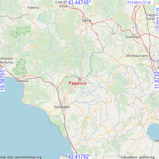
Paganico GPS coordinates[2]
42° 56' 5.46" North, 11° 16' 12.612" East
| Map corner | latitude | longitude |
|---|---|---|
| Upper-left | 43.44748°, | 10.56705° |
| Center: | 42.93485°, | 11.27017° |
| Lower-right: | 42.41792°, | 11.9733° |
| Map W x H: | 114.5×114.5 km | = 71.1×71.1mi |
| max Lat: | 47.04031° ⇑63.7% North |
| Paganico: | 42.93485° |
| min Lat: | ⇓36.3% South 35.50142° |
| min Long | Paganico | max Long |
| 6.69888° | 11.27017° | 18.48682° |
| W 46.4%⇐ | ⇒53.6% E |
Elevation
Elevation of Paganico is 64 m = 210 ft, and this is 242.7 m = 796 ft below average elevation for this country.
| Max E: |
2085 m = 6841 ft | 77% |
| Avg. | 306.7 m = 1006 ft | |
| Paganico | 64 m = 210 ft | |
Min E: |
-4 m = -13 ft | 23% |
See also: Italy elevation on elevation.city.
Geographical zone
Paganico is located in North temperate zone (between Tropic of Cancer and the Arctic Circle). Distance of this Northern Tropic circle is 2168 km =1347.1 mi to South.| Distance of | km | miles | from Paganico |
|---|---|---|---|
| North Pole | 5233.2 | 3251.8 | to North |
| Arctic Circle | 2627.3 | 1632.5 | to North |
| Tropic Cancer | 2168 | 1347.1 | to South |
| Equator | 4773.9 | 2966.4 | to South |


Nearby cities:
15 places around Paganico: (largest is in red/bold)
• Arcidosso
22.8 km =14.2 mi,  107°
107°
• Bagno Roselle
17.4 km =10.8 mi,  217°
217°
• Batignano
11.3 km =7 mi,  228°
228°
• Braccagni
17.5 km =10.9 mi,  246°
246°
• Campagnatico
5.8 km =3.6 mi,  176°
176°
• Castel del Piano
22.4 km =13.9 mi,  102°
102°
• Cinigiano
11.1 km =6.9 mi,  116°
116°
• Civitella Marittima
6.6 km =4.1 mi,  7°
7°
• Istia D'Ombrone-Le Stiacciole
18.2 km =11.3 mi,  201°
201°
• Montalcino
22.2 km =13.8 mi,  53°
53°
• Ribolla
19.5 km =12.1 mi,  281°
281°
• Roccastrada
11.7 km =7.3 mi,  314°
314°
• Roccatederighi
18.5 km =11.5 mi,  303°
303°
• Sassofortino
16.4 km =10.2 mi, 308°
• Sticciano Scalo
12.4 km =7.7 mi,  265°
265°
Sources, notices
• [Note1] Compared only with cities in Italy existing in our database
• [Src1] Map data: © OpenStreetMap contributors (CC-BY-SA)
• [Src2] Other city data from geonames.org with taken over terms of usage.
• [Src3] Geographical zone / Annual Mean Temperature by Robert A. Rohde @ Wikipedia
