Funes - Villnoess geodata
Funes - Villnoess (Trentino-Alto Adige) is a seat of a third-order administrative division; located in Italy in Europe/Rome (GMT+2) time zone. With population of 2,379 people, there are 3663 cities with bigger population in this country. Compared to other cities in Italy, 99.1% of cities are located further ↓South; 51.6% of cities are located further ←West and 98.2% of cities have lower elevation than Funes - Villnoess. Note1


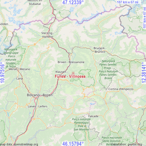
Funes - Villnoess GPS coordinates[2]
46° 38' 34.152" North, 11° 40' 41.808" East
| Map corner | latitude | longitude |
|---|---|---|
| Upper-left | 47.12339°, | 10.97516° |
| Center: | 46.64282°, | 11.67828° |
| Lower-right: | 46.15794°, | 12.38141° |
| Map W x H: | 107.3×107.3 km | = 66.7×66.7mi |
| max Lat: | 47.04031° ⇑0.9% North |
| Funes - Villnoess: | 46.64282° |
| min Lat: | ⇓99.1% South 35.50142° |
| min Long | Funes - Villnoe | max Long |
| 6.69888° | 11.67828° | 18.48682° |
| W 51.6%⇐ | ⇒48.4% E |
Elevation
Elevation of Funes - Villnoess is 1136 m = 3727 ft, and this is 829.3 m = 2721 ft above average elevation for this country.
| Max E: |
2085 m = 6841 ft | 1.8% |
| Funes - Villnoess | 1136 m 3727 ft | |
| Avg. | 306.7 m = 1006 ft | |
Min E: |
-4 m = -13 ft | 98.2% |
See also: Italy elevation on elevation.city.
Geographical zone
Funes - Villnoess is located in North temperate zone (between Tropic of Cancer and the Arctic Circle). Distance of this North polar circle is 2215 km =1376.3 mi to North.| Distance of | km | miles | from Funes - Villnoess |
|---|---|---|---|
| North Pole | 4820.9 | 2995.6 | to North |
| Arctic Circle | 2215 | 1376.3 | to North |
| Tropic Cancer | 2580.3 | 1603.3 | to South |
| Equator | 5186.2 | 3222.6 | to South |


Nearby cities:
15 places around Funes - Villnoess: (largest is in red/bold)
• Albes
5.2 km =3.2 mi,  316°
316°
• Bressanone
8.2 km =5.1 mi,  348°
348°
• Chiusa
8.6 km =5.3 mi,  267°
267°
• Laion
9.4 km =5.8 mi,  245°
245°
• Lazfons
10.1 km =6.3 mi,  287°
287°
• Leone-Santa Elisabetta
10.1 km =6.3 mi, 347°
• Novacella
11.4 km =7.1 mi, 348°
• Ortisei
7.4 km =4.6 mi,  183°
183°
• San Pietro
0.4 km =0.2 mi,  115°
115°
• Sant'Andrea in Monte
6.3 km =3.9 mi,  359°
359°
• Santa Cristina Valgardena
9.8 km =6.1 mi,  155°
155°
• Varna
11.1 km =6.9 mi,  343°
343°
• Velturno
6.8 km =4.2 mi, 293°
• Villandro
10.8 km =6.7 mi,  262°
262°
• Villandro - Villanders
10.9 km =6.8 mi, 262°
Sources, notices
• [Note1] Compared only with cities in Italy existing in our database
• [Src1] Map data: © OpenStreetMap contributors (CC-BY-SA)
• [Src2] Other city data from geonames.org with taken over terms of usage.
• [Src3] Geographical zone / Annual Mean Temperature by Robert A. Rohde @ Wikipedia
